


 menu
Histories of Australian Rock Art Research
7
A short story of Gariwerd: The rock art management chapter
Robert G. Gunn and Jake R. Goodes
Introduction
Archaeologists have determined through archaeological excavations in the region that Aboriginal people have occupied Gariwerd (the Grampians Ranges in western Victoria) for at least 22,000 years (Bird and Frankel 2005). From Aboriginal perspectives, Gariwerd was made by Bunjil in the Dreaming, giving local Aboriginal peoples a charter that says ‘we have always been here’. It is unknown when the first artist put paint to rock in Gariwerd but, on the basis of motif superimpositions and states of preservation, they started a process that continued for generations. This paper presents an outline of the story of Gariwerd’s rock art, its recording, conservation and government management, and the increasing role of Aboriginal Traditional Owner groups in those endeavours.
Since its first recognition by non-Aboriginal Australians, academic attention to the rock art of Gariwerd has undergone a number of discrete phases. Each of these phases has added a new dimension of knowledge on the rock art repertoire and, hence, on the ongoing story of Gariwerd culture.
The Greater Gariwerd rock art region extends beyond the Grampians Ranges (Gariwerd) to include the immediate sandstone outliers of Burrunj (Black Range to the west of Gariwerd), Lil Lil (Red Rock), Punyole (Dundas Range), Dyurrite (Mt Arapiles), Mt Bepcha and Mt Talbot (Figure 7.1). These ranges and outcropping ridges are all composed of the same sandstone strata identified in the main Grampians Ranges (Cayley and Taylor 1997:10). These ranges and outcrops contain a wealth of rock art that together constitutes a broad rock art tradition that contrasts with rock art elsewhere in the State of Victoria (Gunn 1987a). A second Black Range, to the east of the Grampians Ranges, contains the site popularly known as ‘Bunjil’s shelter’. This eastern Black Range is composed of granite and is included within the Greater Gariwerd rock art region on the basis of a documented Aboriginal story connecting Bunjil’s shelter and Gariwerd. The most recent rock art at Bunjil’s shelter, and to which the story relates, is in a distinctly different art style to those styles present elsewhere in Greater Gariwerd, while the underlying art has direct parallel to one of the later styles within Gariwerd (see below).

Figure 7.1: Location of Gariwerd and locations mentioned in the text.
Source: Map by Robert G. Gunn.
The Greater Gariwerd rock art region is within the lands of the Jardwadjali, Djabwurrung and Gunditjmara peoples (Figure 7.1), today represented by the Barengi Gadjin Land Council Aboriginal Corporation, based in the town of Horsham; Eastern Maar Aboriginal Corporation, based in Warrnambool; and Gunditj Mirring Traditional Owners Aboriginal Corporation, based in Heywood.
The Grampians Ranges of Gariwerd are a tightly grouped set of north–south trending quartzose sandstone ranges. The ranges rise steeply from the surrounding plains some 900 m below (Figure 7.2). The rainfall and temperature vary from warm and dry in the north (mean annual rainfall = 448 mm) to cool and wetter in the south (mean annual rainfall = 617 mm). The highest peak in Gariwerd, Duwul (Mt William), at 1167 m above sea level, has a mean annual rainfall of 1166 mm (BOM 2019). Duwul and the other high peaks receive seasonal snow falls every few years.
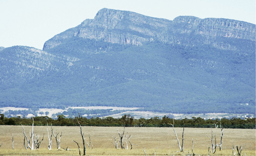
Figure 7.2: Central Gariwerd from the east.
Source: Photograph by R.G. Gunn.
Today, the vegetation across Gariwerd varies from swamp scrub-heathland in the broad valleys, to tall open forest with a dense scrubby understorey and alpine vegetation on the ranges varying with altitude and latitude (Day et al. 1984:40). In 1896, however, the Victoria Range consisted of ‘rocky hills clad lightly with timber’ and was grazed by both sheep and cattle (Mathew 1896:30). The present dense vegetation is thought to be largely the result of the removal of grazing and the cessation of earlier Aboriginal burning practices, as the early settlers ran sheep and could ride horses through much of the ranges (Wilkie 2020:68–76; Eric Barber pers. comm. 2019).
Background
In the beginning
The story of Gariwerd begins with the creation of the land by Bunjil, the creator-being of the Aboriginal peoples of south-eastern Australia (Howitt 1904:289–291). Features of the landscape were later modified by descendent Dreaming Beings, such as Tchingal the Emu who created the landmark features of Jananginj Njaui and Barigar (Figure 7.1). The rock-shelters that now house the rock art were created at the beginning of the Gariwerd story, during the Dreaming creation of the landscape. At this before-time era, Aboriginal peoples had the forms of birds and were capable of supernatural practices. At the era’s end, the bird-people became human, but with the ability to return to their bird-states through appropriate achievements and rituals.
Aboriginal occupation
Aboriginal people have lived in and around Gariwerd from the beginning and continue to be an integral part of Gariwerd. Archaeological excavations have revealed that people have occupied the ranges of Gariwerd since at least 22,140±160 BP (no calibration possible; Bird and Frankel 2005:71). Elsewhere in Victoria, the oldest dated occupation is c. 32,000–26,600 calBP (Richards et al. 2007) but, given that older archaeological sites are known from every Australian state including Tasmania, and that the earliest dated archaeological site elsewhere in Australia dates to c. 65,000 years ago (Clarkson et al. 2017) – Madjedbebe in the Northern Territory – it is expected that further archaeological work will extend the period of human occupation in Victoria, including Gariwerd where (unexcavated and undated) sites are plentiful.
At some unknown time, Aboriginal people began using the rock-shelters of the region to produce pigment rock art. Initially this consisted of red stencils, paintings and prints, with a small number of yellow paintings (see below). Later, they produced a period dominated by dry pigment drawings in red or black. Most recently, white pigment was preferred for painting and drawing, and with the inclusion of a small number of abradings and scratchings into their repertoire (Gunn et al. 2019). The age and degree of overlap or separation of these phases is unknown. Also unknown is the extent to which the most recent art coincided with the impact of the colonial invasion.
Caroline Bird, then of La Trobe University, undertook an excavation of the Mt Talbot 1 rock-shelter, during the course of which art was identified on the shelter’s rear wall (Bird 1986, 1995). She and her students later undertook the first extensive archaeological survey within Grampians National Park, concentrating on exposed sediment surfaces along roads and tracks rather than on the rock-shelters that had been the focus of all previous research (Bird 1989). Although many of the sites they recorded were single artefacts, the work clearly established that Aboriginal occupation extended throughout Gariwerd. Site types located included rock art but also scarred trees, stone quarries, large and small lithic scatters, and isolated artefacts.
During the 1990s and 2000s, a small number of rock art sites were recorded by rock climbers and bushwalkers, but the majority of archaeological information was derived from cultural heritage management plans relating to developments within the Grampians National Park or on adjoining Crown lands (e.g. Cekalovic 2000; Edmonds 1992; Gunn 1999; Gunn and Goodes 2020).
The colonial invasion
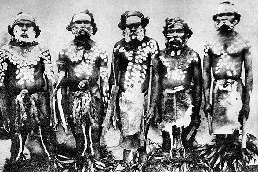
Figure 7.3: Mt Clay tribesmen painted up for Corroboree 1859.
Source: Photograph by Thomas Hannay.
The initial contact of Gariwerd Aboriginal people with Europeans began with the peaceful traversing of the area by Thomas Mitchell’s expedition in 1836 (Mitchell 1839). From 1838, however, the subsequent invasion of the region by European settlers began, and with it the decimation and subjugation of local Aboriginal people (Clark 1990a, 1990b, 1995). No photographs of the Gariwerd people have survived from this time, but one of a group of Gunditjmara men from Mt Clay, to the south, shows them painted up for corroboree (Figure 7.3), with body patterns similar to those depicted on the image of Bunjil at Bunjil’s shelter (see below). Although most of the physical fighting was over by 1848, the battle by Aboriginal people to gain recognition as Australian citizens had to wait for the 1967 Commonwealth Referendum; some sense of justice for the displacement came 26 years later with the Native Title Act 1993 (Cth). No treaty with Aboriginal communities has yet been realised, but the formal participation of the Traditional Owner groups in the ongoing management of Gariwerd is forthcoming (Parks Victoria 2020).
Rock art recording
While numerous references were made to Aboriginal rock art around Sydney soon after the arrival of the British First Fleet in 1788 (e.g. Stockdale 1789), the first acknowledgement of Aboriginal rock art in Victoria was of that at the Billiminah shelter (now Billimina) by John Mathew in 1896, following its finding in 1865–1866 by local landholders Muirhead and Carter from nearby Glenisla Station (Figure 7.4). The existence of rock art in the Victoria Valley, in the centre of Gariwerd, had been earlier mentioned to the anthropologist E.M. Curr as a cavern ‘the roof of which is covered in old Aboriginal paintings’ (Curr 1886:96). This cavern site was most probably one of the three larger art shelters on the Victoria Range (Billimina, Manya or Jananginj Njaui).
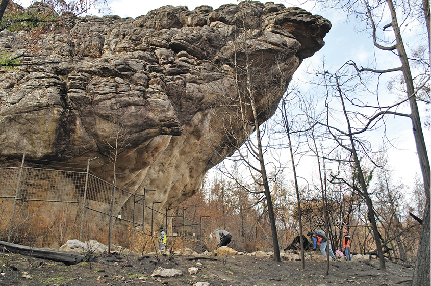
Figure 7.4: Billimina rock-shelter (post-2013 fire).
Source: Photograph by Robert G. Gunn.
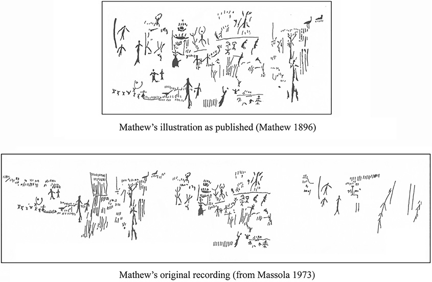
Figure 7.5: Mathew’s drawing of the art at Billimina as published (above) and as originally drawn by him (below).
Source: Mathew 1896; Massola 1973a.
The large and well-decorated site of Billimina was first recorded by A. Ingham in 1894, but his sketchy record was not published until 1912 (Kenyon 1912:107–108). Mathew’s brief publication of Billimina, while documenting the art, also offered an ‘archaeological’ and ethnological appraisal of the site. His observations included the size of the shelter floor, its absence of rubble, a possible banking on the south-western side, and its present use by sheep and cattle. He noted the size of the art panel (11.1 m long, with art extending from 0.9 m to 2.5 m above ground) and that the art consisted ‘chiefly of numerous short upright strokes, a few slightly undulating lines drawn perpendicularly or horizontally, branches, foliage, and figures of animals’ (Mathew 1896:30). Mathew also questioned unnamed Aboriginal Elders about the art, learning that the Elders had seen the paintings when they were young but were unable (or unwilling) to suggest who had painted them or when. One Elder suggested to him that the strokes might have been a ‘record of time during which encampments had been continued at the place’ (Mathew 1896:31). Mathew then gave his own subjective interpretation of 20 sets of motifs, and noted that some of the strokes were later additions as they overlay larger figures. His scale drawing of the site, excluding most of the strokes, was produced with difficulty due to the quantity of graffiti that covered the wall at that time. In a later publication (Kenyon 1912:108), Carter is quoted as saying that the practice of graffiti was begun by shearers from his station around 1875. Mathew’s illustration was substantially rearranged for publication, greatly distorting the scale and visual impression of the panel (Figure 7.5), and causing a number of later general publications to misinterpret the nature of the art (e.g. Davidson 1936; see also Tugby and Tugby 1980).
While at the site, Mathew experimented with making pigment, and was told by Carter that the Aboriginal station hands gathered weathered red ochre from the neighbourhood and mixed it with possum fat for use as raddle for marking rams before they were joined with ewes, however, no source of good quality red ochre has yet been located within the Gariwerd region. Mathew also briefly made mention of a small number of images in a second site close by Billimina (now called ‘GI-02’). As a final note, he compared the images at Billimina with those from the Kimberley and New South Wales, finding the Gariwerd art differed through the use of one colour (red) and infilled body cavities (Mathew 1896:33). By looking at a wide range of contexts for the art, rather than just the images, Mathew raised a higher bar for other recorders to follow.
An early allusion to another Gariwerd rock art site was a passing reference collected by geologist-turned-anthropologist A.W. Howitt (1904:291):
One of the Mukjarawaint said that at one time there was a figure of Bunjil and his dog painted in a small cave behind a large boulder in the Black Range near Stawell, but I have not seen it, nor have I heard of anyone having seen it.
The Mukjarawaint (Jardwadjali) informant was John Connelly (Clark 2002). The location referenced caused a search for the illusive paintings, but most attention was given to looking in the Black Range (Burrunj) to the west of the Grampians, and not to the area also called Black Range on the eastern side of Gariwerd (Ian McCann, local naturalist, pers. comm., 1983). The discovery of Bunjil’s shelter in the eastern Black Range had to wait until the 1950s (see below).
Mathew’s high standard of recording for his time was not, however, followed by subsequent recorders until the 1970s. In 1929, two further rock art sites were recorded in the Grampians: Cave of Red Hands (now Manya) and Cave of Ghosts (now Ngamadjidj). Manya was recorded by C. Barrett (a newspaper reporter) when accompanying anthropologist A.S. Kenyon and artist P. Leason to undertake a tracing of the art at Billimina (Barrett 1929a). At the nearby town of Cavendish they heard of another art site that was well known to local residents: the ‘Cave of Red Hands’. After a quick visit to the site, Barrett published a short article on the ‘cave’ in a Melbourne newspaper, along with a photograph of a set of hand stencils (Barrett 1929b). Kenyon also produced a similar summary report in his book Australian Aboriginal art (Kenyon 1929a). Later that same year, 1929, Kenyon reported on the Ngamadjidj shelter in a newspaper article, but provided only a cursory description of the art ‘in this wild and rugged place’ (Kenyon 1929b). Barrett, Kenyon and S.R. Mitchel, all members of the ethnological section of the Royal Society of Victoria, were also responsible for the construction of protective wire-mesh grilles (cages) at these three art sites in the mid-1930s (Clark 2002:456), the first such measures in Victoria (since replaced by more substantial structures).
In 1943, Barrett reported yet another art site, ‘Brimgower Cave/Cave of Fishes’ (now ‘Larngibunja’). In contrast to his earlier reporting, this record included a more journalistic text and three photographs, although again little archaeological information was included (Barrett 1943).
The art at Billimina (Glenisla) was recorded with colour photographs and watercolour sketches in 1950 by historian Leonard Adams from Melbourne University (with the help of a young John Mulvaney), but apart from a description of the field trip, the results of the recording were never published or otherwise distributed (Adams 1952). In 1953, Donald Tugby, curator of anthropology at the National Museum of Victoria, rerecorded the art at Billimina and undertook an excavation of its deposits. He also excavated the deposits at the nearby Manya Shelter. Only a small section of Tugby’s art recording was published (Tugby and Tugby 1980), and material from his Billimina excavation was not analysed until 1988 (Bird and Frankel 2005:41–42).
Substantial recording of Gariwerd rock art did not begin until the mid-1950s when members of the Field Naturalist Clubs of Stawell and Horsham reported finds to Aldo Massola, the curator of anthropology, 1954–1965, at the National Museum of Victoria (now Museums Victoria). Between 1956 and 1973, Massola published 16 papers in the Victorian Naturalist magazine that described 25 previously unreported rock art sites (Massola 1956a, 1956b, 1957, 1958, 1960a, 1960b, 1962, 1963, 1964a, 1964b, 1967, 1971a, 1971b, 1972, 1973a, 1973b) and a recording of the previously mentioned but not described Ngamadjidj site (Massola 1962). These reports were mostly brief accounts (1–2 pages) with a black-and-white photograph and, in some cases, a rough freehand rendition of selected motifs. These recordings are simple magazine reports rather than academic records (as is also Agar 1966). Massola also espoused a subjective interpretation for the art (e.g. Massola 1973b) but this was based purely on his assumption of one motif type as representing a lizard character, an interpretation that is no longer endorsed by the Aboriginal community or archaeologists. Despite the low standard of recording, Massola’s papers did alert the public, the museum and the Forests Commission of Victoria, who then managed the Grampians State Forest, to the presence of rock art in the region. Massola is also recognised for the years he worked with Aboriginal people throughout Victoria, collecting ‘myths’ and documenting their significant places (e.g. Massola 1968, 1970, 1973c).
In early 1968, Alan West, later curator of anthropology at the Museum of Victoria, and archaeologist Dermot Casey (honorary ethnologist) undertook a test excavation of the Billimina floor deposits but failed to recognise any signs of occupation (Coutts and Lorblanchet 1982:5; see also Bird and Frankel 2005:42).
The 1960s and 1970s saw favourable changes in Australian public and political attitudes towards Aboriginal people, with amendments to the Commonwealth Electoral Act 1962 granting Aboriginal people’s rights to enrol to vote; however, recognition as Australian citizens had to wait for the 1967 Commonwealth Referendum. With these changes, Victoria, and other states, legislated to protect Aboriginal archaeology (then usually referred to as ‘prehistory’). The Archaeological and Aboriginal Relics Preservation Act 1972 (Vic) instituted the setting up of the Archaeological and Aboriginal Relics Office, which in 1975 became the Victoria Archaeological Survey (VAS), and began a program of public education (Coutts 1982a, 1982b). The latter instigated an archaeological site register, a series of detailed regional surveys, excavations and ethnohistoric studies (e.g. Coutts 1981; Coutts et al. 1976, 1978; Presland 1978). These recordings included the standardised documentation of the state’s rock art (Gunn 1981, 1987d).
As part of their program, in 1974 VAS engaged the services of an experienced French rock art specialist, Michel Lorblanchet, to undertake the first comprehensive recording of Gariwerd’s rock art (Coutts and Lorblanchet 1982); he also produced one of Australia’s first rock art conservation reports (Lorblanchet 1975). Lorblanchet’s tracings of the Billimina art panel (Figure 7.6) brought a new standard of recording to Australia, and 25 years after its publication it was still considered by Clark et al. (1999:29) to be ‘one of the most definitive recordings in Australian rock art’. This evaluation still stands in 2021, even though Lorblanchet’s published record was limited to black-and-white photographs and illustrations, and despite a number of very detailed recordings from elsewhere around Australia since.
Following Lorblanchet’s recommendation, VAS replaced nine site grilles and began a range of conservation studies that included some of Australia’s earliest studies of pigment analysis and shelter erosion. These Gariwerd studies paralleled similar movements elsewhere in Australia, where concerns for the preservation and presentation of rock art were taking priority over surveys (e.g. Gale and Jacobs 1987; Pearson 1978; Rosenfeld 1988). In Victoria, as well as grille replacements, these studies resulted in improved signage, boardwalks, silicone driplines, graffiti removal, terrestrial photogrammetry and the monitoring of rock deterioration (e.g. AUSLIG 1990; Gunn 1984; Kosinova Thorn 1988; McConnell 1981). While done with the tacit approval of the Aboriginal community, there was still little engagement of community members in either the decision-making process, training or in the undertaking of the tasks.
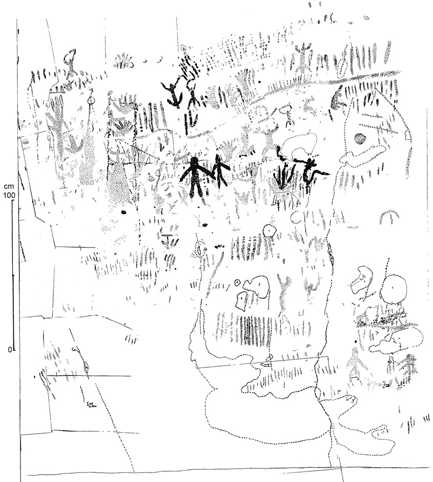
Figure 7.6: Section of Lorblanchet’s 1975 detailed recording of the Billimina art panel.
Source: Courtesy of Michel Lorblanchet.
The recording of rock art continued during the early 1980s, supported by VAS but continuing to be undertaken from a purely archaeological perspective, involving little engagement with or input from Aboriginal community groups with ties to Gariwerd or other local Aboriginal people until the 1990s. These surveys for rock art sites developed a standard recording format with considerably more information than was required on the VAS site forms of the time. At this time, VAS also commissioned the detailed recording of a further 17 Victorian rock art sites, including 12 within Gariwerd (Gunn 1983a, 1983b, 1987b, 1987c) and detailed management plans for eight of the more visited rock art sites in Gariwerd (e.g. Clark 1991a, 1991b).
The period from the 1970s to the 1990s saw Aboriginal voices regarding directions of academic research into their own cultures begin to be increasingly heard throughout Australia (Wallace and Wallace 1977; Langford 1983; Ah Kit 1995).
Over the past 20 years there has been a significant increase in the quality of graphic documentation, description and interpretation for both research and management purposes in Victoria and throughout Australia: a quality that now surpasses the high standard set by Lorblanchet in 1974 (Coutts and Lorblanchet 1982). This is largely due to three significant developments:
- the acknowledgement of Aboriginal people as the rightful custodians of their own cultural heritage and the need to work with full permission, input and involvement of Traditional Owners
- the development of four new archaeological techniques: (1) digital photography that enabled rapid and extensive photography and immediate on-site viewing; (2) to be paired with digital enhancement, especially DStretch colour enhancement (Harman 2008, 2015; Gunn et al. 2010); (3) the Harris Matrix composer for rock art superimposition analysis (Harris and Gunn 2018); and (4) awareness of the Morellian method of recognising contemporaneous motifs (Gunn and Lowish 2017)
- the recognition by management of the need for a detailed record of the sites under their care and also of the need to give Aboriginal cultural sites a high priority for protection and management in a rapidly expanding visitor arena.
In 1992, VAS became Aboriginal Affairs Victoria (AAV), after which it became less directly involved in archaeological research, instead becoming primarily involved in supervision of the standards of pre-development archaeological surveys (now called ‘cultural heritage management plans’ or ‘CHMPs’) undertaken by private consultant archaeologists and Traditional Owner groups. In 2016, VAS/AAV changed its name again to become Aboriginal Victoria. The revised site recording system for the Victorian Aboriginal Heritage Register (VAHR), the state’s formal site register, began to require a greater level of data collection for all cultural heritage sites, including rock art sites. The VAHR recording requirements continue to be periodically revised; however, they now require sub-metre GPS readings and mapping aids that necessitate specialist input. Detailed rock art recordings are now primarily the work of consultants acting for site managers.
Traditional Owner involvements
In 1984, the greater part of Gariwerd was transferred from the Forest Commission of Victoria (Grampians State Forest) to the Victorian National Parks Service as the Grampians National Park. One of the determining values for National Park status was recognition of the area’s Aboriginal cultural values (Day et al. 1984), particularly its rock art. The change in administration also saw the need to involve local Aboriginal people in the park’s management, and to this end the state government began a process that eventuated in the opening to the public of the Brambuk Cultural Centre in 1990. Brambuk, built by the state government for the park, was owned and operated by a joint body of representatives of each of the five Aboriginal communities who had associations to Country in the National Park. At the same time, there was a concerted effort to restore Aboriginal place names throughout the National Park and surrounding region (e.g. Gunn 1989; Clark and Harradine 1990), a movement supported by the publication of Ian Clark’s authoritative reassessment of the distribution of the western Victorian Aboriginal languages and clans during the contact period (Clark 1990a).
While Aboriginal rock art and involvement had been tangentially mentioned in several books on the Grampians National Park (e.g. Calder 1987), in 1999 Aboriginal Affairs Victoria published the first book dedicated to Gariwerd Aboriginal heritage (Wettenhall 1999). At the same time, Brambuk began to sell a range of books on Aboriginal culture in south-east Australia, alongside mainstream books on the natural values of the National Park. Today, there are three groups that represent the Aboriginal Traditional Owner groups of the Gariwerd area: Barengi Gadjin Land Council Aboriginal Corporation, Eastern Maar Aboriginal Corporation and Gunditj Mirring Traditional Owners Aboriginal Corporation. Through these representative bodies, local Aboriginal people have an active engagement in management decisions and employment in works programs. The park, however, still remains to be formally committed as a jointly managed park.
Despite Parks Victoria running several trainee programs for Aboriginal people, most trainees did not remain in the Grampians National Park but moved on to higher positions in Parks Victoria or elsewhere. It was not until 2003 that Parks Victoria created a dedicated Aboriginal ranger position within the Grampians National Park, and in 2016 a rock art specialist position was created to oversee the management of all rock art sites within Crown Reserves across the state.
Discussion
The recording of Gariwerd rock art has been marked by a number of phases with different outcomes. Largely as a result of the different aims of the recorders, the recordings have not necessarily improved over time. Similarly, the reasons or driving force behind the recordings also varied (Figure 7.7), with casual recording by interested amateurs or professionals being paramount. These divisions are not exclusive, but indicate the prime driver in each period.
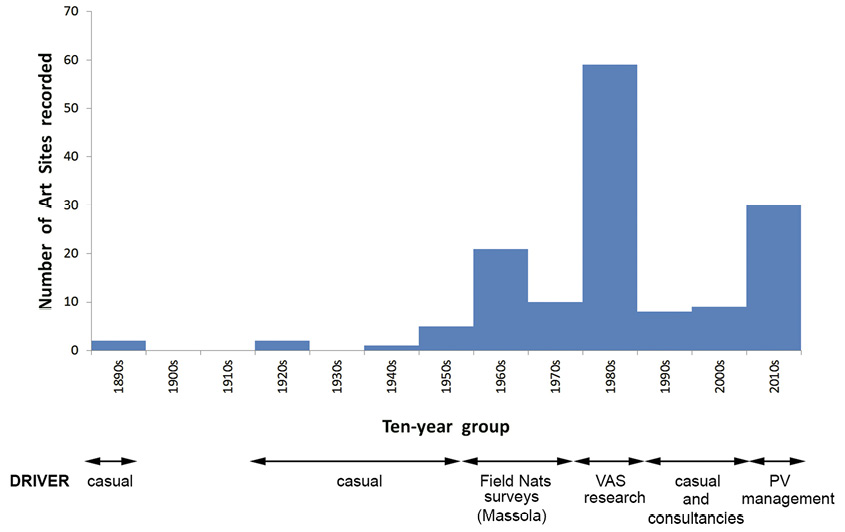
Figure 7.7: Drivers behind Victorian rock art recording.
Source: Photograph by Robert G. Gunn.
The peak period of recording was from 1979 to 1985 when VAS employed a consultant to rerecord known sites and to undertake surveys of adjacent areas, resulting in the recording of a further 58 rock art sites. The state of the art was then summarised and a preliminary analysis undertaken in an unpublished report (Gunn 1987a).
A second peak period of archaeological activity has been ongoing since 2014, resulting from post-fire assessments of the condition of the known rock art sites following three major bushfires that decimated 90 per cent of the Grampians National Park. In 2006, bushfires ravaged the central and southern areas of the park; in 2013, the Victoria Range in the west of the National Park; and in 2014, the northern ranges. During the site assessments, Parks Victoria staff and Aboriginal community members located a large number of unrecorded sites in the burnt-out landscapes. The greater visibility and access to previously unassessed rock outcrops, also occasioned a small number of other unrecorded sites to be reported by bushwalkers, rock climbers and Parks Victoria staff involved in other activities.
The initial peak period of recording activity in the 1960s derived from the work of the local Field Naturalist Clubs from 1956 to 1973. Some of these sites were found during field trips exploring the ‘natural’ world of the park, but other rock art sites were identified during dedicated trips searching for rock art as new areas of the then Grampians State Forest were made more accessible with the construction of new logging tracks (Ian McCann and Eric Barber, local long-time residents, pers. comm. 1981). Following the findings of these keen amateurs, the National Museum of Victoria was contacted and Massola then recorded and published the sites.
What we have learned
The geographical pattern of site locations throughout Greater Gariwerd was essentially set by the work of the Field Naturalist members in the 1960s (Figure 7.8). This pattern was expanded during the 1980s–1990s, and then again in the most recent concerted efforts. With each pulse of activity, new areas have been surveyed and previous areas consolidated with additional surveys. From personal observation and from reviewing of aerial photographs, however, several large areas of the National Park and surrounding ranges still remain to be systematically surveyed. From the amount of exposed rock outcrops in these unexplored areas, we anticipate that the density of sites away from the Victoria Range will likely increase with further surveys.
Our knowledge of the art has also continually expanded over time. In the 1950s, with 10 known sites, the art was seen to consist of red paintings and hand stencils, and a single site containing white painting. Today, with 155 known sites, we have a repertoire comprised of paintings, drawings, stencil and prints in red; paintings and drawings in white; paintings in yellow and drawings in black as well as a small number of scratchings, poundings and abradings (Gunn and Goodes 2018; Gunn et al. 2019). In contrast, the range of motifs has changed little from the earliest recordings, confirming that there is a standard repertoire of rock art types throughout Greater Gariwerd over time, with only minor local variations. The red paintings are dominated by elongated, static or standardised anthropomorphic stick figures, rows of short bars, long lines, ovals and bird tracks; red drawings are dominated by animated anthropomorphic stick figures and bar rows; black drawings are dominated by animated stick figures, emu-like birds and bar rows; and white paintings by bird tracks, bar clusters and animated stick figures. Petroglyphs (scratched, abraded and pounded) have been reported from only two sites to date (Gunn 1981, 1987d; and pers. observations).
Red is the most frequent and widespread colour. Some motif types occur in relatively high numbers at one particular site while occurring only in small numbers elsewhere: hand stencils at Manya in the Victoria Range; hand prints at Gulgurn Manya at the northern tip of Gariwerd; red bars at Billimina; red elongated anthropomorphic stick figures at Gunangidura in the centre of the Victoria Range; white anthropomorphic stick figures at Ngamadjidj in northern Gariwerd, while drawings in red or black are widespread throughout.
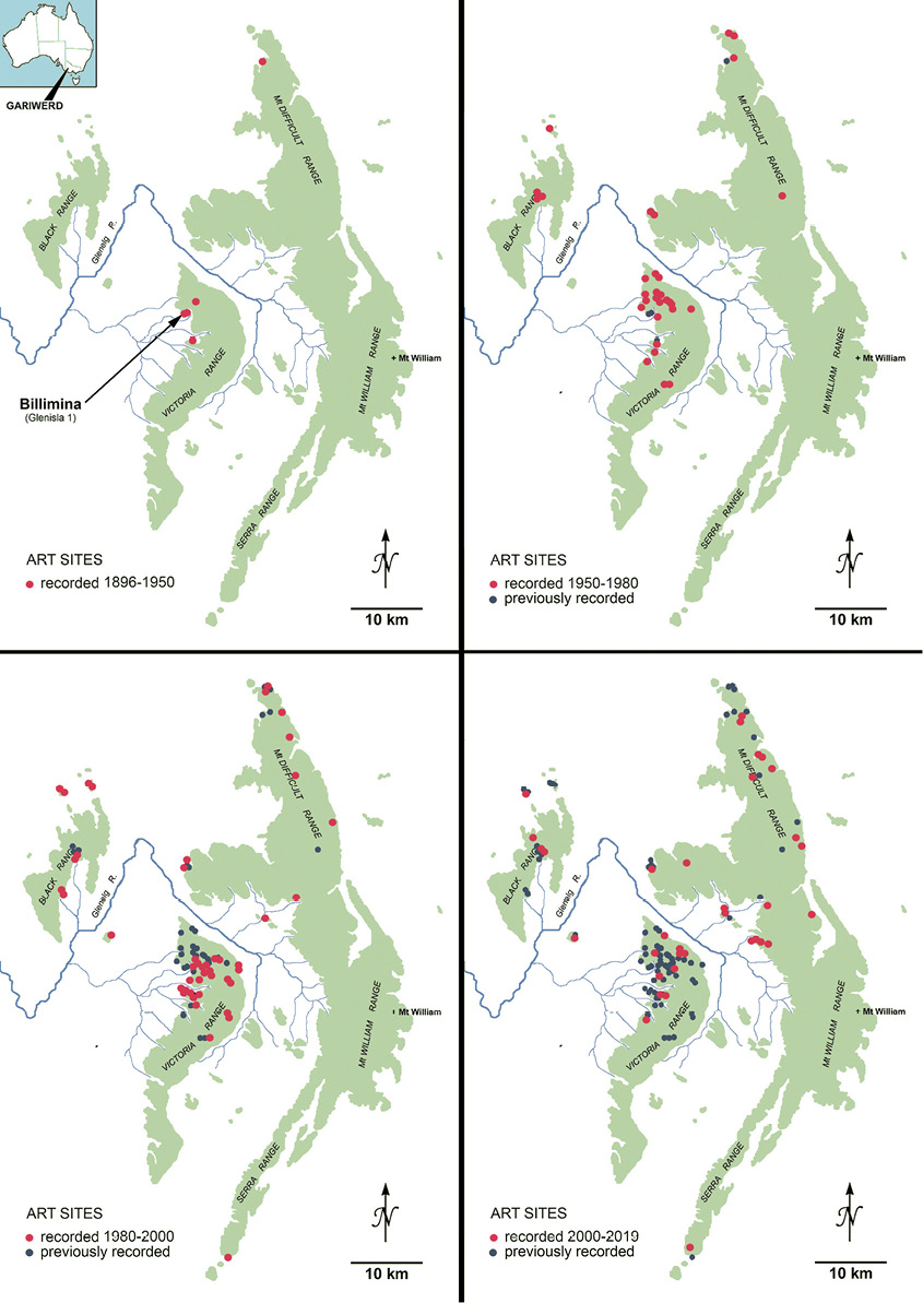
Figure 7.8: Patterns of site recording 1896–2019.
Source: Photograph by Robert G. Gunn.
One of the most recent findings was not made in the field but in the studies of Ian Clark from Federation University, Ballarat. Following his lifelong interest in the region, he came across an early record of a cosmogonic story that connects Gariwerd to Bunjil’s shelter in the granite rocks of the Black Range (Clark 2017). This story describes the descent of Bunjil and his family (including his mother-in-law) down the eastern cliffs of Gariwerd, Bunjil’s fight with the Bunyip at Mokepilly waterhole, midway between Gariwerd and the Black Range, where Bunjil’s shelter is located, and the subsequent painting of the event in Bunjil’s shelter (see also Howitt 1904). The representation of Bunjil in the Black Range, in a very different style to other rock art images known from Gariwerd, along with its linking originary story, now requires that the Greater Gariwerd rock art region be expanded from the sandstone ranges to include this exceptionally important but otherwise isolated art site (Figure 7.1).
Conclusion
The story of Gariwerd and its rock art has a long history, but it also has a living presence and encouraging future. This paper has only considered the rock art and what we have learned about it. It highlights the lack of Aboriginal involvement prior to the 1990s, but also looks forward to a period of greater participation and leadership in documenting and assessing the irreplaceable realities of the rock art of Greater Gariwerd. There is much more to be done and so the story must continue.
Acknowledgements
We thank the three Traditional Owner groups (Barengi Gadjin Land Council Aboriginal Corporation, Eastern Maar Aboriginal Corporation and Gunditj Mirring Traditional Owners Aboriginal Corporation) who have supported this and other rock art projects within Greater Gariwerd. The work has also been assisted by Parks Victoria, Halls Gap. We are grateful to Leigh Douglas and two anonymous referees who made helpful suggestions with content and grammar.
References
Adam, L. 1952. The rock paintings near Glen Isla, Victoria Range, Victoria. Mankind 4:343–344. doi.org/10.1111/j.1835-9310.1952.tb00260.x.
Agar, J.M. 1966. A new painted rock shelter in the Victoria Range. Victorian Naturalist 83:199–201.
Ah Kit, J. 1995. Aboriginal rock art imagery and ownership of ‘research’. In G.K. Ward and L.A. Ward (eds), Management of rock imagery, pp. 36–38. Occasional AURA Publication No 9. Australian Rock Art Research Association, Melbourne.
AUSLIG 1990. Terrestrial photography, Aboriginal rock art, the Grampians, Victoria. Unpublished report of the Australian Surveying and Land Information Group, Department of Administrative Services, Canberra.
Barrett, C. 1929a. Cave hunting and what we found. Australian Museum Magazine 3(12):414–419.
Barrett, C. 1929b. Mysterious cave in the Grampians. Herald, 2 March 1929:1.
Barrett, C. 1943. New primitive art gallery. Wildlife 5:124–126.
Bird, C.F.M. 1986. Excavations at Mount Talbot 1 (VAS 7323/75). Unpublished report to the Victoria Archaeological Survey, Melbourne.
Bird, C.F.M. 1989. Archaeological field survey in the Grampians National Park, 1988. Unpublished report. Department of Archaeology, La Trobe University, Bundoora.
Bird, C.F.M. 1995. Mount Talbot 1: A rock-shelter in the southern Wimmera, Victoria. The Artefact 18:12–21.
Bird, C.F.M. and D. Frankel 2005. An archaeology of Gariwerd: From Pleistocene to Holocene in Western Victoria. Tempus 8. University of Queensland, St Lucia.
BOM (Bureau of Meteorology) 2019. Climate statistics for Australian locations. Available at: www.bom.gov.au/climate/data/index.shtml (accessed 23 April 2019).
Calder, J. 1987. The Grampians: A noble range. Victorian National Parks Association, Melbourne.
Cayley, R.A. and D.H. Taylor 1997. Grampians special map area geological report. Geological Survey Report 107. Natural Resources and Environment, Melbourne.
Cekalovic, H. 2000. Archaeological surveys of Boroka and Balconies/Reed Visitor nodes, Grampians. Unpublished report of Biosis Research to Parks Victoria.
Clark, I.D. 1990a. Aboriginal languages and clans: An historical atlas of Western and Central Victoria 1800–1900. Monash Publications in Geography Number 37. Monash University, Clayton.
Clark, I.D. 1990b. The difficulty of determining pre-contact Aboriginal spatial organisation: Case studies from south western Victoria. Melbourne History Journal 20:66–85.
Clark, I.D. 1991a. Billimina Shelter (‘Glenisla Shelter’) VAS Site 7323/1: A history of management and intervention. Unpublished report to the Victoria Archaeological Survey, Melbourne.
Clark, I.D. 1991b. Manya Shelter (‘Cave of Hands’) VAS Site 7323/4: A history of management and intervention. Unpublished report to the Victoria Archaeological Survey, Melbourne.
Clark, I. 1995. Scars in the landscape. Australian Institute of Aboriginal and Torres Strait Islander Studies, Canberra.
Clark, I.D. 2002. Rock art sites in Victoria, Australia: A management history framework. Tourism Management 23:455–464. doi.org/10.1016/s0261-5177(02)00011-0.
Clark, I.D. 2017. Bunyip, Bunjil and mother-in-law avoidance: New insights into the interpretation of Bunjils shelter, Victoria, Australia. Rock Art Research 34(2):189–192.
Clark, I.D. and L.L. Harradine 1990. The restoration of Jardwajali and Djab wurrong names for rock art sites and landscape features in and around the Grampians National Park. Submission to the Victorian Place Names Committee by the Koorie Tourism Unit of the Victorian Tourism Commission, Melbourne.
Clark, I., A. Long and R.G. Gunn 1999. History of scientific research and documentation. In A. Long (ed.), Billimina shelter (AAV 7323-1) management plan, pp. 21–36. Unpublished report to the South West Rock Art Committee.
Clarkson, C., Z. Jacobs, B. Marwick, R. Fullagar, L. Wallis, M. Smith, R.G. Roberts, E. Hayes, K. Lowe, X. Carah, S.A. Florin, J. McNeil, D. Cox, L.J. Arnold, Q. Hua, J. Huntley, H.E.A. Brand, T. Manne, A. Fairbairn, J. Shulmeister, L. Lyle, M. Salinas, M. Page, K. Connell, G. Park, K. Norman, T. Murphy and C. Pardoe 2017. Human occupation of northern Australia by 65,000 years ago. Nature 547:306–310. doi.org/10.1038/nature22968.
Coutts, P.J.F. 1981. Readings in Victorian prehistory, Vol. 2. Ministry for Conservation, Melbourne.
Coutts, P.J.F. 1982a. Victoria Archaeological Survey activities report 1979–80. Records of the Victoria Archaeological Survey 13:1–28.
Coutts, P.J.F. 1982b. Management of Aboriginal cultural heritage in Victoria. Records of the Victoria Archaeological Survey 13:85–114.
Coutts, P.J.F. and M. Lorblanchet 1982. Aborigines and rock art in the Grampians. Records of the Victoria Archaeological Survey No 12. Ministry for Conservation, Melbourne.
Coutts, P.J.F., R.K. Frank and P. Hughes 1978. Aboriginal engineers of the Western District, Victoria. Records of the Victorian Archaeological Survey 7. Ministry for Conservation, Melbourne.
Coutts, P.J.F., D. Witter, M. McIlwraith and R. Frank 1976. The mound people of Western Victoria. Records of the Victoria Archaeological Survey No 1. Ministry for Conservation, Melbourne.
Curr, E.M. 1886. The Australian race: Its origins, languages, customs, places of landing in Australia, and the routes by which it spread itself over that continent. Volume 1. Victorian Government Printer, Melbourne.
Davidson, D.S. 1936. Aboriginal Australian and Tasmanian rock carvings and paintings. Memoirs of the American Philosophical Society No 5. American Philosophical Society, Philadelphia.
Day, J.C., G.A. McGregor and P.D. Johnstone 1984. Grampians National Park: Inventory of resources and uses. National Parks Service, Melbourne.
Edmonds, V. 1992. Mt Arapiles – Tooen State Park archaeological survey. Unpublished report to the Goolum-Goolum Aboriginal Cooperative, Horsham.
Gale, F. and J.M. Jacobs 1987. Tourism and the national estate. Australian Government Publishing Service, Canberra.
Gunn, R.G. 1981. The prehistoric rock art sites of Victoria: A catalogue. Occasional Report Series No 5. Victoria Archaeological Survey, Melbourne.
Gunn, R.G. 1983a. Aboriginal rock art in the Grampians. Records of the Victorian Archaeological Survey No 16. Ministry for Conservation, Melbourne.
Gunn, R.G. 1983b. The Cave of Ghosts Aboriginal rock art site. Occasional Report Series No 12. Victorian Archaeological Survey, Melbourne.
Gunn, R.G. 1984. Fire and the preservation of rock art: Assessment of the effects of a fuel reduction burn on archaeological sites in the Victoria Range, Grampians. Unpublished report to the Victoria Archaeological Survey, Melbourne.
Gunn, R.G. 1987a. Aboriginal rock art in Victoria. Unpublished report to the Victoria Archaeological Survey, Melbourne.
Gunn, R.G. 1987b. Flat Rock 1 Aboriginal rock art site. Unpublished report to the Victoria Archaeological Survey, Melbourne.
Gunn, R.G. 1987c. BR2 and the art of the Black Range, Western Grampians. Unpublished report to the Victoria Archaeological Survey, Melbourne.
Gunn, R.G. 1987d. Second catalogue of Victorian rock art sites. Unpublished report to the Victoria Archaeological Survey, Melbourne.
Gunn, R.G. 1989. Alternative names for rock art sites and natural features in the Grampians National Park. Unpublished report to Victorian Tourist Commission, Melbourne.
Gunn, R.G. 1999. Grampians National Park development sites: Archaeological survey. Unpublished report to Parks Victoria, Halls Gap.
Gunn, R.G. and J. Goodes 2018. Wartook Lookout 1 (WO-1) and the Gariwerd rock art sequence, Victoria. In C. Spry, E. Foley, D. Frankel, S. Lawrence, I. Berelov and S. Canning (eds), Excavations, surveys and heritage management in Victoria 7, pp. 7–11. La Trobe University, Melbourne.
Gunn, R.G. and J. Goodes 2020. Grampians National Park SPAs: Aboriginal rock art site impact assessments. Unpublished report to Parks Victoria, Melbourne.
Gunn, R.G. and S. Lowish 2017. The Morellian method and its potential in rock art research. Rock Art Research 34(2):193–205.
Gunn, R.G., C.L. Ogleby, D. Lee and R.L. Whear 2010. A method to visually rationalise superimposed pigment motifs. Rock Art Research 27(2):131–136.
Gunn, R.G. J. Goodes and L.C. Douglas 2019. Gariwerd petroglyphs and their situation within the Gariwerd rock art sequence. The Artefact 42:17–27.
Harman, J. 2008. Using decorrelation stretch to enhance rock art images. DStretch. Available at: www.dstretch.com/AlgorithmDescription.html (accessed 12 April 2009). Paper originally presented at American Rock Art Research Association Annual Meeting, 2005.
Harman, J. 2015. Using DStretch for rock art recording. INORA 72:24–30.
Harris, E.C. and R.G. Gunn 2018. The use of Harris Matrices in rock art research. In B. David and I. McNiven (eds), The Oxford handbook of the archaeology and anthropology of rock art, pp. 911–926. Oxford University Press, Oxford. doi.org/10.1093/oxfordhb/9780190607357.013.18.
Howitt, A.W. 1904. The native tribes of South Eastern Australia. MacMillan, London.
Kenyon, A.S. 1912. Camping places of the Aborigines of south-east Australia. Victorian Historical Magazine 2:97–110.
Kenyon, A.S. 1929a. Australian Aboriginal art. National Museum of Victoria, Melbourne.
Kenyon, A.S. 1929b. Correspondence. Ararat Advertiser, 11 April 1929:1.
Kosinova Thorn 1988. Bunjils Cave: A report on the removal of recent overpaint. Unpublished report to the Victoria Archaeological Survey, Melbourne.
Langford, R. 1983. Our heritage – your playground. Australian Archaeology 16:1–6. doi.org/10.1080/03122417.1983.12092875.
Lorblanchet, M. 1975. Erosion in the Grampians Mountains. Unpublished report to the Australian Institute of Aboriginal Studies, Canberra.
Massola, A. 1956a. Aboriginal paintings at the Flat Rock shelter. Victorian Naturalist 73:21–23.
Massola, A. 1956b. More paintings at Flat Rock. Victorian Naturalist 73:65–67.
Massola, A. 1957. Bunjil’s cave found. Victorian Naturalist 74:19–22.
Massola, A. 1958. New Aboriginal rock paintings in the Victoria Range. Victorian Naturalist 75:73–78.
Massola, A. 1960a. Two new painted shelters at Glenisla. Victorian Naturalist 76:234–235.
Massola, A. 1960b. The shelter at the Camp of the Emu’s Foot. Victorian Naturalist 77:188–191.
Massola, A. 1962. The Cave of Ghosts. Victorian Naturalist 78:335–337.
Massola, A. 1963. Black Range shelters. Victorian Naturalist 79:169–176.
Massola, A. 1964a. Records of new shelters in the Black Range. Victorian Naturalist 81:15–17.
Massola, A. 1964b. Victoria Range shelters. Victorian Naturalist 81:169–176.
Massola, A. 1967. Honeysuckle Creek rock shelters. Victorian Naturalist 84:264–266.
Massola, A. 1968. Bunjil’s cave: Myth, legends and superstitions of the Aborigines of south-eastern Australia. Lansdowne Press, Melbourne.
Massola, A. 1970. Aboriginal mission stations in Victoria. Hawthorn Press, Melbourne.
Massola, A. 1971a. Boggy Creek painted shelter: A new locality recorded. Victorian Naturalist 88:152–154.
Massola, A. 1971b. Aboriginal paintings at Muline Creek. Victorian Naturalist 89:139–141.
Massola, A. 1972. Honeysuckle Creek No. 4 Aboriginal shelter. Victorian Naturalist 89:196–197.
Massola, A. 1973a. Report on new discoveries and notes on an older Aboriginal painted shelter in the Victoria Range, Grampians. Victorian Naturalist 90:280–285.
Massola, A. 1973b. The ‘Matterhorn’ Aboriginal shelter and its possible mythological significance. Victorian Naturalist 90(11):326–327.
Massola, A. 1973c. An Avoca River–-Wirrengren Plain Aboriginal track route. Victorian Naturalist 90:126–131.
Mathew, J. 1896. Notes on an Aboriginal rock painting in the Victoria Range, County of Dundas. Proceedings of the Royal Society of Victoria 9:29–33.
McConnell, A. 1981. Preliminary report: Grampian’s art conservation project 1977–1981. Unpublished report of the Victoria Archaeological Survey, Melbourne.
Mitchell, T.L. 1839. Three expeditions into the interior of eastern Australia. Boone, London.
Parks Victoria 2020. Greater Gariwerd landscape draft management plan. Parks Victoria, Melbourne.
Pearson, C. (ed.) 1978. Conservation of rock art. ICCM, Sydney.
Presland, G. (ed.) 1978. Journals of George Augustus Robinson: March–May 1847. Records of the Victorian Archaeological Survey No 5. Ministry for Conservation, Melbourne.
Richards, T., C. Pavlides, K. Walshe, H. Webber and R. Johnston 2007. Box Gully: New evidence for Aboriginal occupation of Australia south of the Murray prior to the Last Glacial Maximum. Archaeology in Oceania 42:1–11. doi.org/10.1002/j.1834-4453.2007.tb00001.x.
Rosenfeld, A. 1988. Rock art conservation in Australia. Australian Government Publishing Service, Canberra.
Stockdale, J. (ed.) 1789. The voyage of Governor Phillip to Botany Bay. John Stockdale, London.
Tugby, D.J. and E. Tugby 1980. The Reverend John Mathew and painted rock: Perception and cognition in the recording and reproduction of an Aboriginal rock painting in the Grampians, Victoria. The Artefact 5:123–143.
Wallace, P. and N. Wallace 1977. Killing me softly: The destruction of a heritage. Nelson, Melbourne.
Wettenhall, G. 1999. The people of Gariwerd: The Grampians’ Aboriginal heritage. Aboriginal Affairs Victoria, Melbourne.
Wilkie, B. 2020. Gariwerd: An environmental history of the Grampians. CSIRO Publishing, Melbourne. doi.org/10.1071/9781486307692.
Previous Next