


 menu
A Memory of Ice
8
It is a sight far exceeding anything I could imagine and which is very much heightened by the idea that we have penetrated far farther than was once thought practicable, and there is a sort of awe that steals over us all in considering our own total insignificance and helplessness.
Joseph Hooker, letter to his father Sir William Hooker, Hobart Town, 8 April 1841
Erebus – Name of a place of darkness, between Earth and Hades.
Oxford English Dictionary
Erebus – in Greek mythology: a place of darkness in the underworld on the way to Hades.
Merriam Webster Dictionary
The diary
Thursday 25 January 1973
Just a bird report for a start, as I have to work up a contribution to this afternoon’s Ross Sea discussion. This morning, with a weak bit of sun, we saw the most birds yet—albatross all of one kind—black on the wings and stretching right across the body—white body, black beneath the wings—I suspect they are black-browed, or could they be Royal? Storm petrels are coming in close, Wilson or Leach’s—deeply forked tail is clear? Lots of Antarctic fulmars, few Cape petrels, some Antarctic petrels.
There is a pair of snow petrels outside now, with their lovely wheeling flight.
There was a wonderful iceberg at about 9pm last night—tabular, with 3 deep blue caves indenting it … a lovely bridge at one end. Sketched it quickly.
Monday 29 January 1973
We are now at a latitude exceeding 77o South as we approach Site 270 (Site 7) of our cruise. I wrote home last night in the hope that there will be a mail pickup from the US icebreaker now close to us. The weather changed this morning to a threatening grey sky, windy and with a heavy sea. All along the starboard side of the foredeck the spray has frozen into regular foot-long icicles—there are ice curtains fringing all the pipes and rails—I took some photos, but the cold was too painful to stay out long. Then I spent a couple of hours re-sampling a core, down in the core-vans, which are just within the steel shell of the ship below the forward decks—it was actually warmer in the refrigerated core storage units than outside them! I am now thawing out.
We enjoyed a rendezvous with the US Coastguard icebreaker Northwind. This was a small-scale social event. She was hove to—a small, round-bellied grey ship, and we came up to within a few hundred yards. Our mail was brought across in a flat-bottomed landing craft manned by beardless boys in light denim jackets, who had trouble holding their awkward vessel alongside, as it was wallowing and bumping in a nearly flat sea. There was no mail—not for me and not for many others—we suspect it hasn’t been passed on by Scripps (Scripps Institute of Oceanography, San Diego).
The Northwind has been assigned to escort us through the hazards of the Ross Sea—this is because the Glomar Challenger is not ice strengthened. From the Operations Report it’s evident that the Northwind explored 5 or 6 miles ahead to find the best route through the pack ice—not necessarily where the pack was lightest, but where there was less of the ‘hard’ blue ice that might damage our hull. We followed the Northwind closely, staying 600 to 1000 yards in her wake. As we approached, a curious Russian whaler was circling her erratically, so all of a sudden the usually empty sea was full of ships.
The Antarctic petrels are here in flocks of a hundred or more—lovely, heavy chocolate brown and white birds; the heads very dark—they come in right over the ship, obviously curious. There are always more birds when the sea is choppy than when it is flat calm.
I slept through the first pack ice the other morning, and so have probably missed all the seals and penguins we will ever see!
There is too much to record! I have given two talks this past week—one on the preliminary stratigraphy of the sites so far, and one on Antarctic vegetation history. The discussions have been strenuous. The co-chief scientists (Denny and Larry) are rather aggressive and highly competitive during these sessions. Our other sedimentologist is quick tempered and goes red to the roots of his hair when he fails to win his point. Others, fortunately, are steady. These are strange sessions. They are difficult because the problems we are trying to grasp are difficult, and no one alone can get there, but the men make it harder because of their competitiveness … or have we just been at sea too long at this stage?
Tuesday 30 January 1973
Site 270 Site 7 (77o26.48′S; 178o30.19′W) Water depth 633 m.
Occupied 30 January – 2 February 1973
On site at Site 270—about 50 miles from the Great Ice Barrier. The drilling isn’t going very well. We soon went into hard tillite—a mix of unsorted glacial rocks and consolidated sediment—so the drilling is slow, and there is poor recovery of core. The chances of my getting hold of a good section, rich in pollen, are getting slimmer.
A bright sunny day has emerged from the morning’s light snow—there is no ice anywhere, just a sparkling blue-green sunny sea. We had barbecued steaks on the fantail for dinner last night in a remarkably comfortable temperature. In the afternoon we were visited by hordes of fresh-faced boys from the US Coastguard icebreaker Northwind.
I’m beginning to wish the sun would set—it’s 10pm, and I am dog-tired after a 3am start, but I can’t shut it out of my porthole. It will drop a bit lower and light the cabin still further, then begin its gentle upward climb. I feel like putting on pyjamas and going properly to bed!
Wednesday 31 January 1973
Today there is a couple of inches of snow all over the decks—it hasn’t stopped snowing all day—the seas are high, but we are holding our position well. Wretched glacial sediments have wiped me out—core is stacking up in the corelab …
Site 271 Site 8 (76o43.27′S; 175o02.86′W) Water depth 562 m.
Occupied 3–5 February 1973
Site 272 Site 9 (77o07.62′S; 176o45.61′W) Water depth 619 m.
Occupied 6–8 February 1973
Bergy bits and tough drilling
My diary ends here, probably because of pressure of work, with the need to write up the results before the end of the cruise in Christchurch in late February. We drilled three more holes in the Ross Sea after Site 270 (Sites 271, 272, 273), all on the Antarctic continental shelf. Water depths ranged from 490 to 650 metres, shallower than any we had previously drilled. This meant that the core barrels came on deck more quickly than at sites further out to sea, although not always with good recovery of core. The continental shelf of Antarctica is deeper overall than most of those of other continents, averaging depths of 500 metres, but there are often deeper inner troughs—all due to the weight of ice on the continent.
Our mission, in January and February of 1973, was one of the first to seek to uncover something of the history of the Ross Ice Shelf. How long had the mass of ice that now fills the marine basin been in existence and is there evidence for its expansion and retreat since its beginning? What effect might it have had on ocean waters to the north?
Three of the drill holes were positioned so that they intersected a seaward-dipping surface, a surface that cuts across the sedimentary strata and must have been planed off by earlier expansion of the ice shelf.
My role here was a dual one—to document the sediments, but also to select and sample sediments that could yield hints of the vegetation that might have covered the area before the ice shelf, or in the early stages of ice sheet development.
All the drill holes penetrated glacial sediments—monotonous pebbly silty clays probably as old as Early Miocene or Late Oligocene (around 26–20 million years old), far older than any previous considerations. These were tough and hard sediments; slow to drill, even slower to record. They are full of pebbles, dropped into place from floating or grinding ice. To understand what these might mean in terms of the extent and nature of the ice, the pebbles must be recorded, picked out of the cores so that they might later be measured, scrutinised for their rock type, examined for the tell-tale marks of striations on their surface; analysed for their chemistry. The meticulous picking out of the pebbles by eye fell to Peter and Art, but the slowness of the procedure meant that cores were stacking up in the core lab awaiting description.
Site 273 Site 10 (74o32.29′S; 174o37.57′E) Water depth 491 m.
Occupied 10–13 February 1973
There were some problems, too, in manoeuvring to stay on these sites. Some of these were to do with the ship’s gyro compass, but there was also the ever-present danger of icebergs. At Site 273 in the western Ross Sea it became evident that small icebergs—bergy bits—were on a track towards the drill site; another US icebreaker, the Burton Island, was on hand to deflect these. The Operations Report records that a large bergy bit—one that was described as about one-third of the icebreaker in size—seemed determined to cross the Glomar Challenger’s path. The Burton Island again pushed the bergy bit away; when pushed it would twist and roll off the icebreaker’s bow. The Burton Island suffered damage to her bow above the ice belt—the reinforced zone around the ship’s hull—while pushing away the troublesome lump of ice, but her actions saved the drill site. The icebreaker gave the appearance then of limping off, wounded, not to be seen again until we reached Christchurch.
All the sites drilled by the Glomar Challenger in the Ross Sea were positioned to show something of the age and history of the Ross Ice Shelf—when did it begin? How has it fluctuated through time? They were partially successful, showing that glacial sediments had been deposited there in the Ross Sea since at least the Oligocene about 26 million years ago. Three of the drill holes (Sites 270, 271 and 272) revealed a surface suggesting that the sedimentary sequence had in the past been planed off, presumably by an ice shelf that had expanded beyond its present limits. This must have happened somewhere in the interval between 3 and 5 million years ago.
The glacial pebbles (clasts) in these drill holes suggested that they had been transported by glaciers arising from Marie Byrd Land east of the sites—part of West Antarctica. At Site 273, sited on the edge of a submarine escarpment in the west central sector of the Ross Sea, the ice-rafted clasts contained fragments from the Transantarctic Mountains.
The Ross Sea gas
The drill bit penetrated gaseous hydrocarbons at Sites 271, 272 and 273. The ominous swelling of parts of the core barrels when they came on deck was clear evidence of this, and caused alarm.
Drilling was stopped immediately at all three sites. There is a danger of fire from gaseous blowouts in real or potential oil and gas fields, and the Glomar Challenger didn’t carry any device used to stifle or prevent such blowouts. In addition, it is possible that gas bubbling up into seawater can cause a loss of buoyancy that could cause a ship to sink.
Site 271 was the first where bubbles of gas were encountered, the cores coming on board swollen and literally bulging at the seams. At Site 272 gas was present in the cores whenever adequate sediment samples were recovered. The gaseous bulges caused alarm when the cores were brought on deck. The sense of alarm was mostly due to worries about the loss of buoyancy; this danger is reputed to be greatest in shallow water, and we were certainly in that. We were all too aware that a vessel—the Sedco Helen—supplying a drilling rig in Western Australia’s Bonaparte Gulf had sunk with a significant loss of life just the year before, possibly from a related phenomenon, although this was not proven.
So in an atmosphere of tension these holes were terminated. But the process of getting off the sites seemed interminably long, as the drill string had to be retrieved piece by piece, recovery of the string usually taking the best part of a long tense day.
The gases that Leg 28 encountered in the Ross Sea were a mixture of methane and ethane. The methane could result from the rotting of organic matter, and considering the abundance of diatoms and diatom-rich oozes in this region there could be plenty of such matter. The ethane could come from the heating of gases with depth, and their migration upwards; this could mean that deeper rocks in the sequence were going through the processes that could lead to maturing of the organic matter. The ethane was particularly abundant in Site 271.
We were at pains to play down the significance of these finds in commercial terms. An attempt was made to discourage thoughts of an association of the area with areas of oil production such as the Gippsland Basin of Victoria and the Taranaki oil fields of New Zealand, areas that would have been adjacent to the Ross Sea region prior to the rifting apart of these continental blocks. It was stressed, too, that in areas outside Antarctica where hydrocarbons are produced, these usually come from much older rocks—and certainly not from anything like the pebbly silty clays that distinguish the Ross Sea sediments. Nevertheless, in spite of the conservative reporting of these finds, the global press was quick to jump on them as indicating a real potential for commercial exploitation.
The timing of these discoveries gave an added urgency to assessing their potential in global markets. In 1973 the effects of international politics on energy resources were being widely felt. After the Yom Kippur War, when Egypt and Syria launched a surprise attack on Israel, and the United States retaliated by supplying arms to Israel, the countries that comprised the Organization of Arab Petroleum Exporting Countries imposed an embargo on the export of petroleum to certain Western countries, including the United States, the United Kingdom and Canada. This, although it was resolved under the hand of Henry Kissinger in 1974, caused an upsurge of interest in the potential of new areas for hydrocarbon exploration, and Antarctica was perceived as being significant in that search.
At the conclusion of the drilling program, the final report of the Leg 28 cruise warned that, with respect to the presence of hydrocarbons:
It is extremely premature to attach any economic significance to the Ross Sea hydrocarbons at this time. Their presence in a shallow-water, thick Tertiary sequence will logically and hopefully lead to a close examination of their potential. It may, however, lead to wishful and wild speculation regarding reserves on the Antarctic continent and new negotiations within the Antarctic Treaty organization addressing the economic potential of the Antarctic continent. (Hayes and Frakes 1975, p.940)
As predicted, the occurrences did indeed generate wishful and wild speculation in the global financial press and were highlighted in the Wall Street Journal in 1974. Wildly speculative estimates of the hydrocarbon potential of Antarctica have regularly followed. For instance, a figure that suggests some 50 billion barrels might be available beneath the Ross and Weddell seas has been quoted, and the figure of a total of 203 billion barrels for the whole continent crops up frequently (see, for example, the 2011 report of the Australian Lowy Institute). The recent surge of interest, by the Chinese Government in particular, to establish new bases in Antarctica brings the issue up again, with resources being suspected as the underlying motive.
The politics of Antarctica are complex but are historically based on the Antarctic Treaty that was brought into being during the unease following the Cold War, when it was feared the continent might be exploited for military and intelligence purposes. In 1959 the Treaty was negotiated by a group of nations including those who had previously laid territorial claims to much of the Antarctic continent. These claims were suspended with the Treaty’s entry into force in 1961. From the 12 original signatories, the number of participants has grown to 53 in 2017. Another 29 states have ‘consultative status’, allowing them to vote on Antarctic administrative issues.
The supplement to the Treaty most relevant to the issue of hydrocarbons is the Protocol on Environmental Protection to the Antarctic Treaty—the ‘Madrid Protocol’—adopted in 1991. Article 7 of the Madrid Protocol simply states: ‘Any activity relating to mineral resources, other than scientific research, shall be prohibited’.
There is currently some unease relating to a possible review of the Treaty in 2048 in the light of increased current interest in Antarctica from a variety of nations. How might such a review affect the operation of the Madrid Protocol and the continued prohibition of any non-scientific activities relating to mineral resources, interpreted broadly to include hydrocarbons?
While there may be some differences of legal opinion on this, the view of a former director of Australia’s Antarctic Division, Dr Tony Press, who in 2014 headed an inquiry into Australia’s aspirations in Antarctica is relevant. He suggested then that there is little likelihood that the ban on such activity would expire in any 2048 review—he regarded the prohibition as indefinite (Press 2014, p.47).
Given this legal ban, and current concerns about fossil fuel use in the light of increased global temperatures, future exploitation of Antarctica’s hydrocarbon resources seems improbable. And the commercial significance of the gas encountered in our Ross Sea drill holes seems to be receding!
Recently, biological conservation has replaced the focus on commercial exploitation—including hydrocarbons—in the Ross Sea. The richness and biological diversity of the present sea have stimulated the designation of much of the marine realm as a vast Marine Protected Area. This aims to protect the region from human activities that could affect the diversity and existing ecosystems. Commercial fishing will be allowed only outside ‘no-take’ zones, which comprise some 72 per cent of the area, while some fishing activities would be allowed in other parts for scientific purposes only. The declaration of the Ross Sea as a protected area has been developed over several years under the aegis of the Commission for the Conservation of Antarctic Marine Living Resources—or CCAMLR—and was originally steered by the United States and New Zealand, before the agreement of all 24 parties to the Commission was reached in 2015, after many of the scientific issues and the appropriate boundaries were agreed. The Marine Protected Area came into force in December 2017. It will offer protection to the habitats for several species of whales and seals, to fish, to birds such as the iconic Emperor Penguin, and to a diversity of invertebrates—notably to the krill that form the base of the food chain.
The Ross Sea and Ross Ice Shelf
Glomar Challenger’s four drill holes in the Ross Sea were taking us close to some of Antarctica’s historic places. The Ross Sea is named for its English discoverer, Captain James Clark Ross of the British navy, commanding the vessels Erebus and Terror. It is flanked on its western edge by the Transantarctic Mountains that stretch across the entire continent, rising to a height of some 4,500 metres and consisting of a number of separate mountain ranges. This solid, essentially land-based East Antarctica differs from West Antarctica, which rests on a more marine footing. The massive Ross Ice Shelf presently covers much of the Ross Sea. A thick plate of ice, the bulk of it lying beneath the ocean surface, fills the southern part of the wide bay, extending from McMurdo Sound eastwards to the icecap of West Antarctica. About the size of France, it may be up to 750 metres thick, with its maximum thickness in its southern areas. Glaciers that originate in both East and West Antarctica feed it.
The northern, seaward boundary of the ice shelf—Ross’s Great Ice Barrier—is a vertical wall of ice up to 50 metres in height. Impressed by the sudden appearance of this white wall, and daunted by such an impediment to his desire to sail further south, Ross wrote in his journal that ‘we might with equal chance try to sail through the cliffs of Dover as to penetrate such a mass’ (Ross 1847, vol. 1, p.219).
The ice shelf receives ice from the continent through a pattern of ice streams—discrete channels where ice flows at rates of up to 800 metres per year. These streams join to form the ice shelf. Satellite images show a pattern of ‘flow stripes’ on the surface of the shelf, formed when there is flow around an elevation or obstacle; crevasses forming there make a pattern that is preserved by ongoing flow within the shelf.
Ice shelves generally buttress the flow of ice from the continent, acting as a brake on ice that would otherwise flow directly into the sea. Their removal by melting could cause a sea-level rise of around 5 metres should the West Antarctic Ice Sheet melt. Ice shelves on the Antarctic Peninsula have recently collapsed abruptly—the Larsen B ice shelf collapsed in March 2002, and the Wilkins Ice Shelf began to show evidence of disintegration in 2008. In 2017 a giant crack or many-branched rift appeared in the Larsen C ice shelf, eventually allowing the release of an iceberg twice the size of Luxembourg to pass into the Weddell Sea. It is thought to be among the 10 largest icebergs known from Antarctica. The removal of the buttressing effect of these shelves has meant an increase in ice flow around the sites, with glaciers flowing into the sea some three to four times faster than previously. The melting process contributes to sea-level rise.
Investigating the history of the ice shelf
The nature of the Ross Ice Shelf has been investigated by several programs that drill through the ice to sample the seawater and sediments below. In an early attempt in the Ross Ice Shelf Project—RISP—a first hole was drilled early in 1976 but, because the ice is moving, the drill bit became stuck in the hole some 90 metres from the base of the ice and it was necessary to shift the locality. A second drill bit equipped with a kind of flamethrower allowed better penetration. Cameras lowered through the second hole, some 450 kilometres from the ice front, provided the first sight of unique life forms on the sea floor below—fish, crustaceans and a variety of bacteria and microplankton were thriving in the sub-ice environment. Melting of the ice seemed to be occurring at the base, but this may have been seasonal. The age of the seabed below—probably Middle Miocene (around 15 million years old)—was obtained by microfossils in short cores taken in the sediments.
There seems to be an insatiable appetite for understanding the nature and history of this massive ice shelf. Following the RISP there have been many attempts to drill the sea floor, most using annual sea-ice as a platform, all designed to understand the development of the ice shelf and the way it is linked to the history of uplift of the Transantarctic Mountains. A plethora of acronyms reflects this, most relating to projects close to McMurdo Sound, an area providing a critical insight into events in the wider Ross Sea region. Hence there have been drilling projects such as McMurdo Sound Sediment and Tectonic Studies (MSSTS), Cenozoic Investigations in the Ross Sea (CIROS) and the Cape Roberts Drilling Project (CRP), all reflecting the complexity in planning at international level, the difficulties of executing drilling into the seabed and the difficulties of interpreting the results of these projects, which date back to the mid-1980s.
The momentum to understand the recent history of major Antarctic ice development continues, and another international project, the Antarctic Drilling Project (ANDRILL), in the northwestern corner of the Ross Ice Shelf, where the smaller McMurdo Ice Shelf is fed by glaciers flowing from the East Antarctic Ice Sheet in the Transantarctic Mountains, was begun in 2006. Its aim was to obtain sediment cores that ‘provide a unique record of the history of the Ross Ice Shelf and Antarctic Ice Sheets spanning the last 20 million years’. Cores from one of these boreholes, number 2A, drilled from ‘fast ice’—that is, ice attached to the coastline—showed very rapid swings in climate in the early part of the Miocene (probably 15–20 million years ago). This was interpreted to mean that ice sheets grew and retreated rapidly, possibly in response to changes in atmospheric CO2 levels. This result was surprising, because it suggests that the great ice sheet of East Antarctica—long considered more stable and less prone to melting than the West Antarctic Ice Sheet—may in fact not be as secure as was imagined. Should this be the case, then sea-level changes associated with melting of the East Antarctic Ice Sheet might be more extreme than once thought. Palaeoclimate data from this project are being integrated with the latest ice sheet models to better predict the future response of Antarctic ice sheets to global warming.
A pollen record was extracted from these drill hole cores. The detail in Chapter 9 shows an increase in plant cover during the warm phases—perhaps a tundra-like vegetation with low trees of beech and conifers may have existed during phases of less intense glaciation, provided that sufficient water was available.
A stepping-off point
The flat surface of the Ross Ice Shelf made it appealing as a base for early explorers who then headed south towards the pole. After the Erebus and Terror expedition, there was a long period in which only vessels in pursuit of seals and whales penetrated into the Ross Sea. In 1895 the Norwegian whaling ship Antarctic landed at Cape Adare, at the seaward entrance to the Ross Sea, the first confirmed landing on the Antarctic continent. On board was the Norwegian-born adventurer Carsten Borchgrevink. Blunt and unlikable, yet dynamic, he was keen to make a further expedition. After an unsuccessful fund-raising tour of England he raised private funds for a small expedition. His party landed at Cape Adare in February 1899 and set up the first shore base on the Antarctic continent. In the following January, after the return of the Antarctic to collect them, the party sailed south to the Great Ice Barrier, then sledged southward on the barrier surface to reach a new ‘furthest South’ at 78o50′S in February 1900.
During a conference of the Royal Geographical Society in 1893, Sir John Murray, who had sailed with the Challenger Expedition, pushed strongly for further British expeditions in the name of science; the Royal Society strongly supported this push and a surge in government funded expeditions followed. The first was the Discovery Expedition led by naval officer Robert Scott, which included figures later to be prominent in the Heroic Age of Antarctic exploration—Ernest Shackleton, Edward Wilson and Frank Crean. Permanent quarters for Scott’s party were established in McMurdo Sound. A rocky peninsula in the sound, Hut Point, was the site of living and working quarters, while the Discovery was allowed to be frozen in for the duration of the winter—for several winters as it turned out. From its ice shelf base, members of the expedition ascended the polar plateau to the east, mapped part of the Transantarctic Mountains, discovered the enigmatic Dry Valleys and collected thousands of geological and biological specimens including the first plant fossils of Glossopteris in Antarctica.
The Nimrod Expedition of 1907–09 to Antarctica under Ernest Shackleton was also based on the Ross Ice Shelf. In fact, too close to Scott’s base. This apparently caused some friction between the two explorers when Scott claimed priority rights to McMurdo Sound. The Nimrod Expedition failed to reach the South Pole, but did achieve south latitude of 88o28′S. A party from the Nimrod Expedition led by Australian geologist Edgeworth David reached a probable location of the South Magnetic Pole and another ascended Mt Erebus.
A new hut on Ross Island, some 20 kilometres to the north of Hut Point, was to serve as Captain Scott’s departure point when he embarked on what was to become, in January 1912, his fatal attempt on the South Pole.
Roald Amundsen, however, reached the South Pole in December 1911 from the Bay of Whales, an indented section of the ice barrier. His encampment there, Framheim, was named for his Norwegian-built ship the Fram. The site was some 60 kilometres closer to the pole than Scott’s base.
Searching for the South Magnetic Pole
The search for the South Magnetic Pole by a party led by Edgeworth David on the Nimrod Expedition is part of a history of research into Earth’s magnetism that has played a role in Antarctic exploration since around the middle of the nineteenth century. There had been little scientific interest in Antarctica since Cook’s circumnavigation of the continent in the course of his second expedition of 1772–76. His bleak analysis of the geography described the southern polar continent—if it existed at all—as lying in an inhospitable region of ice and snow. This discouraged the setting up of government-supported expeditions for some 60 years. His revelation of the enormous numbers of seals and whales to be found in those latitudes brought a flood of activity of a different kind. Between the years 1784 and 1822 huge numbers of seals were slaughtered in a wide swathe across the islands of the Antarctic Peninsula, the coasts of Chile and the subantarctic islands of the Atlantic and Indian oceans. Seals were driven to near extinction during this phase, and inroads were made into the populations of whales and elephant seals.
The involvement of both the British and Russian governments followed the seal hunters. New lands, subsequently revealed to be islands, were discovered off the Antarctic Peninsula. The British Royal Navy sent Edward Bransfield to the area to explore the area and establish whether these sightings might have been part of a larger landmass. He sighted the mountains of the Antarctic Peninsula—possibly the first sight of the Antarctic mainland—and sailed into the Weddell Sea. The Russian expedition in the sloops Mirny and Vostok twice circumnavigated the continent, crossing the Antarctic Circle for the first time since Cook.
But overall there was little scientific interest in Antarctica until a little later, centred on 1840, when three major national expeditions were launched, from France, Britain and the United States. All were supported by their national governments, and by learned societies, particularly in Britain by the Royal Society and the British Association for the Advancement of Science. But while this rebirth of interest in Antarctica was at least in part scientific—and focused on Earth’s magnetism—there was as well a great deal of political, imperial interest. National pride was as strong as scientific curiosity.
Interest in Earth magnetism has a long history; the observation that Earth acts as a giant magnet goes back to at least the early 1600s. Map-maker Geradus Mercator in 1580 noted that the nearer you are to the North Pole ‘the nearer you come unto it, the more the needle of the compass doth vary from the North’ (Hakluyt 1982, p.209). And Edmond Halley produced charts in 1701 and 1702 showing that compass readings in the Atlantic did indeed vary from true north. It was observed that the dip of the compass needle increased in its angle as ships sailed closer to the North Pole. All such observations stressed the profound practical importance to navigation of a better understanding of Earth’s magnetism.
One of the gentlemen of influence urging more profound studies of magnetic phenomena was Alexander von Humboldt, scientist, explorer and philosopher. Von Humboldt’s massive 1852 work on the geography and natural history of South America and his vision that understanding the ‘unity of nature’ might be achieved through the interrelation of the sciences of biology, meteorology and geology had deeply influenced Darwin, Wallace and Joseph Hooker as well as a wider public. With the support of the Russian Government, von Humboldt had already organised a chain of magnetic and meteorological observatories across northern Asia. This effort impressed Edward Sabine, an astronomer and later President of the Royal Society, who had been appointed one of three scientific advisors to the Admiralty after the abolition of the Board of Longitude in 1828. Sabine embraced the cause of magnetic observatories, urging the British Government to set up a series through the southern hemisphere, including the Cape of Good Hope, Tasmania and potentially in Antarctica, to determine the strength of magnetism and the position of the South Magnetic Pole. When his initial call on the British Government failed, Sabine enlisted the support of von Humboldt, who wrote to the then president of the Royal Society and whose influential plea swayed the British scientific establishment.
This led to the selection of James Clark Ross to command an expedition to high southern latitudes with the purpose of setting up observatories and finding the South Magnetic Pole. Ross already had considerable experience of sailing in icy regions—he had accompanied his uncle Sir John Ross on Arctic voyages in search of a northwest passage. On one of those voyages in 1831 he seems, according to historical accounts, to have personally located the North Magnetic Pole in northern Canada.
Efforts to locate the magnetic poles were inherently frustrating. Both the north and south magnetic poles shift—sometimes by a few kilometres a day—but knowing their location has great value for navigation, so that a lot of exploration history is centred on their search. After Ross’s location of the North Magnetic Pole in Canada in 1831, the South Magnetic Pole was not really located until 2000, when the use of more modern equipment enabled Canberra geophysicist Charles Barton to locate it at sea. Earlier expeditions, first under Shackleton and later including Mawson, sought it on land and came close.
The planned British expedition under Ross was not the first to get underway. That record fell to the French, under Admiral Jules César Dumont d’Urville. He was a very experienced and skilled sailor—some say every bit as good as James Cook. An intriguing and complex character, he was well versed in the classics as well as navigation and natural history. But at over 50 he considered himself old, perhaps doubting his own capacity as leader.
Dumont d’Urville wrote to the naval ministry in 1837, suggesting that France should make a new voyage into the Pacific. It was approved by King Louis Philippe who also ordered that the voyage should aim for the South Magnetic Pole. If this could not be located, then the vessels should try to equal or exceed the most southerly latitude—74oS—reached by the Englishman James Weddell in 1823. Clearly, in this venture French pride was as strong as scientific curiosity.
The vessels in which Dumont d’Urville was to meet the objectives set out for him were not equipped for such high latitudes. They were two navy corvettes, the Astrolabe and the Zélée. Nevertheless they did sight and, indeed, land on Antarctica—a part of East Antarctica that he named Terre Adélie after his wife. The landing point is controversial and was probably a small rocky island offshore. Nevertheless they poured there a libation of the best French Bordeaux. And they did come close to locating the South Magnetic Pole.
The voyages of the Erebus and Terror

Figure 8.1. James Clark Ross. Lithograph by Thomas Herbert Maguire, 1851.
Source: Courtesy of National Library of Australia.
A much reproduced portrait of James Clark Ross shows him very artfully posed as a Byronic figure, clad in a rich fur, with a ceremonial sword tightly clasped across his chest, with the pole star and magnetic dip instruments in the background. The image reproduced here (Figure 8.1), a lithograph by the English portraitist and lithographer Thomas Herbert Maguire, shows a 51-year-old Ross, perhaps more quietly assured than in his assumed Byronic youth. Maguire was lithographer to Queen Victoria; those who were depicted in his portraits included such scientific greats as Charles Darwin, Robert Brown, William Buckland, Adam Sedgwick and Richard Owen—names prominently associated with the development of the biological and geological sciences in nineteenth-century Britain.
With the French, and the Americans under Charles Wilkes, already in the field, the British were becoming a little edgy. But in spite of the need for haste, planning of the expedition was meticulous. For vessels, Ross selected the Erebus and Terror. These were known as ‘Bomb vessels’ because they had previously been used to fire mortar bombs that were launched at shore batteries rather than at other vessels at sea. This meant that their hulls had been especially strengthened to withstand recoil from the bombs—oak beams and double sheathing with copper gave robustness. A layer of dreadnought cloth—thick woollen material—between decks provided further strengthening, and a system for circulating warm air throughout the vessels was added before the ships sailed for the Antarctic. Thus they were well prepared for polar exploration.
Ross’s expedition sailed from Britain in the autumn of 1839. Its official aims were quite modest and essentially scientific; to establish weather stations and also a series of stations for the measurement of Earth’s magnetism. But in reality, the imperialistic drive, the will not to be outdone by the French or Americans, was very strong. It was only on arrival in Hobart that Ross learnt of Dumont d’Urville’s discoveries to the south. There he also found that the American Charles Wilkes had left a letter for him, accompanied by copies of his charts for his perusal, showing the extent of his discoveries. The gesture was an unusual one for the usually imperious Wilkes, who had not revealed information during his stay in Sydney. Ross was careful to express his gratitude to Wilkes, but felt that the information provided by the American commander was not as useful as he had hoped. Further, he felt it necessary to assert British pride as he planned his own voyage south, writing in his journal that:
England had ever led the way of discovery in the southern as well as the northern regions, I consider it would have been inconsistent with the pre-eminence she has ever maintained, if we were to follow in the footsteps of any other nation. (Ross 1847, vol. 1, p.116)
So Ross changed his planned course. Instead of sailing due south, he voyaged to where stories from sealers showed the pack ice to fall away suddenly to the south, and where one might get closer to the pole. He was also well aware of the superior ice-strengthening of the British ships when compared to those of the French and Americans.
In sailing east as well as south they entered what is now known as the Ross Sea, reaching 74oS before they were stopped by the cliffs of the Great Ice Barrier. They had sailed close to the Transantarctic Mountains. That disappointed Ross because he recognised that the South Magnetic Pole must be situated inland and he would not be able to reach it by sea. They were stunned to discover an enormous active volcano, which they named Erebus. The young Joseph Hooker, botanist to the expedition, best described their astonishment at the landscape. In a letter to his father from Hobart Town, on 8 April 1841, he wrote:
At one time we thought we were really going to the true South Pole, when we were brought up by the land turning from S to E, where there was a fine volcano spouting fire and smoke in 79 degrees S, covered all over with eternal snow except just round the crater where the heat had melted it off … to see the dark cloud of smoke tinged with flame rising from the volcano in one column, one side jet black and the other reflecting the colours of the sun, turning off at a right angle by some current of wind; it is a sight far exceeding anything I could imagine and which is very much heightened by the idea that we have penetrated far farther than was once thought practicable, and there is a sort of awe that steals over us all in considering our own total insignificance and helplessness. (Huxley 1918)
Ross laid claim—without going ashore—to a large tract of land in the name of Queen Victoria. The expedition did eventually make a landing on a small island on the edge of the Ross Sea, which they promptly named Possession Island. This was early in 1841 on the first of three journeys to the edge of Antarctica. The following summer they tried again, but were hopelessly trapped in pack ice—taking some weeks to break free and enduring a drastic collision between the two ships. Fortunately they were able to repair the damage.
James Clark Ross, then, has to his credit the discovery of the Transantarctic Mountains, one of the longest mountain ranges on Earth. Ross’s expedition sailed along the coast of Victoria Land from 70oS. He wrote: ‘we shaped our course directly for the magnetic pole, steering as nearly south by compass as the wind admitted’. Where the dip of the compass needle reached 86 degrees, the South Magnetic Pole could not have been more than 500 miles (805 kilometres) from their locality. But the presence of land ‘rising in lofty peaks, entirely covered with perennial snow’ interposed as an insuperable obstacle to the vessel reaching it.
Disappointed in their expectations of reaching the magnetic pole, Ross consoled himself in his diary—‘yet those mountains being in our way restored to England the honour of the discovery of the southernmost known land’. Ever the naval man, he proceeded to name individual peaks after individual Lords Commissioners of the Admiralty, under whose orders he was serving, and showing his gratitude for the efficient manner in which the expedition’s ships had been fitted out. Indeed, his diary heaps praise upon the heads of these gentlemen—expressing for Sir John Barrow (Second Secretary of the Admiralty) the hope that—with God’s guidance—he might live to see the discovery of the legendary northwest passage.
Further south, peaks of the mountain chain, measured as some 12,000–14,000 feet (3,600–4,200 metres), were named after eminent philosophers of the Royal Society and the British Association who had supported the expedition.
But it was necessary to find a landing place in order to undertake the formalities required to secure possession of this new and forbidding land for imperial Britain. The shores of the mainland appeared inaccessible, with ice projecting into the sea and a heavy surf, so a small island was selected as a landing point. This was made on a beach of loose stones and stranded masses of ice and the newly discovered lands formally possessed ‘in the name of our Most Gracious Sovereign Queen Victoria’.
The British flag was planted, hearty cheers given and the appropriate toasts drunk, with measures of grog given to the boats’ crews. Meanwhile on this fragment of land, Possession Island, hordes of penguins attacked the legs of the landing party, who had to endure the ‘insupportable stench’ of the deep layers of guano in which they were forced to stand. On a practical note, Ross observed that the guano might at some future date be valuable ‘to the agriculturalists of our Australian colonies’ (Ross 1847, vol. 1, p.189).

Figure 8.2. Possession Island. Watercolour by John Edward Davis.
Source: Courtesy of Scott Polar Research Institute, Cambridge, UK.
The following summer the expedition made another attempt into the Ross Sea. This was marked by extreme difficulties, including nearly two months frozen into pack ice. After being freed into a wild sea of moving icebergs there was a collision between Erebus and Terror, with substantial damage to each. A little further south was achieved before the vessels retreated northward to the Falkland Islands. From there, in December 1842, a third voyage was attempted, to the Antarctic Peninsula and into the Weddell Sea, but again they were beset by pack, so set sail for England, arriving at Folkestone in September 1843.
Given the length of the entire venture into Antarctic waters, and with this pattern of retreating to more temperate climates in between, it is surprising that there was relatively little emphasis on the collection of natural history material. Collections made by Joseph Hooker were a marked exception. But the appointed naturalist, Robert McCormick, seemed to have little interest in furthering knowledge in this sphere, although his interest in rock collecting is on record.
Ross may well have been following naval instructions in placing the emphasis of the voyage on navigational matters and on the search for the South Magnetic Pole. But his apparently casual approach to these opportunities for furthering science is evident in the fact that it was after his death, in 1862, that Joseph Hooker found samples collected on the voyage in the back garden of the Ross home in Aylesbury.
Joseph Dalton Hooker and the Flora Antarctica
The botanist Joseph Hooker was an important member of the Erebus and Terror expedition. Hooker’s place in this narrative is appropriate as, although he was unable to collect any higher plants from Antarctica itself, his studies of the plants of southern high-latitude islands and continents led him to believe that a formerly vegetated Antarctica would have been the source of the modern floras.
Further, he was to become one of the nineteenth century’s most significant scientists, although his contributions to plant science are often overshadowed by his friendship with Charles Darwin. In his role as friend and confidant he was influential in urging Darwin to publish his On the Origin of Species in 1859. Theirs was a friendship built not only on their pervading interest in natural science, but also on their ability to share and enjoy stories of voyages in southern seas.
Hooker was just 22 when he joined the expedition. He was first classed as Assistant Surgeon, but, after a somewhat cheeky coercion of Captain Ross, his role was officially changed to that of ‘botanist’, a title that would assure him of productive time ashore throughout the long voyage. He had qualified in medicine, somewhat reluctantly, but was keen to follow in the footsteps of his father, Sir William Hooker, as a botanist. Joseph Hooker saw that extensive travel of this kind was a pathway to fame. It provided a way of inventing a professional role in a time before degrees in science were available. Darwin served as a model for this, but Hooker lacked the family wealth that allowed Darwin to pursue his scientific interests. The Antarctic voyage, Hooker perceived, would provide him with the opportunity to produce the publications necessary to establish his reputation and set him up to apply later for any scientific positions.
Botany wasn’t high on the list of objectives for the voyage, but there were opportunities for work in the field—this was particularly so on such a long voyage. When the vessels were close to Antarctica, Hooker’s captain, James Ross, was certainly pessimistic about the chances of recovering plant material; in his diary Ross teased young Hooker, writing that he had seen not the slightest trace of vegetation, from this concluding that its total absence meant that ‘the vegetable kingdom has no representative in Antarctic lands’ (Ross 1847, vol. 1, p.215).
But in the seasons between the approaches to the ice, when the ships retreated to more temperate harbours, such as those in Tasmania and New Zealand, even to the Subantarctic island of Kerguelen, Hooker was able, with the help of local collectors, to make major studies of these southern floras. In fact the strategy of the three-year expedition, with voyages towards the pole interspersed with sorties into more temperate regions, gave the young botanist unparalleled opportunities to observe the flora of high southern landmasses and islands.
This allowed him to begin to draw the ‘big picture’ stuff—not just of local plant species, but also of the relationship between the different floras—this he knew would establish his name more firmly as a notable scientist. The success of his ground plan was significant enough for him to ultimately succeed his father as Director of the Royal Botanic Gardens, Kew, in 1865.
During the voyage, young Joseph was able to maintain a surprisingly active correspondence with his father, in which he often received stern parental directives concerning the ways in which he should be recording the floras encountered throughout the voyage. Sir William Hooker managed to keep in touch with his son through what must have been a sporadic correspondence, given the length of time it would have taken for letters to arrive at widely spaced localities. Much of Hooker’s correspondence is available to us in Leonard Huxley’s two-volume Life and Letters of Sir Joseph Dalton Hooker, published in 1918, with an input from Lady Hooker. It is evident that Sir William was keen that the young botanist should maintain the highest standard in his description of the floras he encountered, and he also urged that Joseph devote some of his energies to the description of selected plant groups as a way of establishing his reputation.
The windswept Kerguelen Archipelago in the southern Indian Ocean provided Joseph with such an opportunity. He was probably happiest of all of the ship’s company to spend a comparatively lengthy time in this bleakest of landscapes. Working under appalling weather conditions, Joseph was able to spend much of the two and a half months there happily collecting some 150 species of the local flora—more than doubling the previous records—while the officers erected and manned a magnetic observatory. Much of Hooker’s collection consisted of mosses, lichens and algae, which in some cases he was forced to collect by hammering out pieces of the rock on which they grew—sometimes sitting on them to thaw out the little plants. The Kerguelen cabbage also fascinated him—a striking flowering plant that James Cook, on his third voyage in 1776, discovered possessed antiscorbutic properties. Hooker provided a formal description of Pringlea antiscorbutica and ensured that the cabbage, now known to have a high content of potassium and an oil rich in vitamin C, was daily served to the expedition’s crew to accompany their diet of salt beef, pork and the local seabirds. The response of the ship’s crew to their serve of daily greens is unrecorded.
Kerguelen was to Joseph Hooker what the Galapagos Islands were to Charles Darwin—localities whose ecosystems provided the young scientists with a focus for the ideas that were to drive and distinguish their later careers.
The scope of the ports of call of the expedition enabled Joseph Hooker to subsequently compile the botanical findings in his Flora Antarctica, more formally entitled The Botany of the Antarctic Voyage of H.M. Discovery Ships Erebus and Terror, in the years 1839–1843, under the command of Captain Sir James Clark Ross. This massive work, published in four volumes between the years 1844 and 1859, included the floras of the Subantarctic islands and of New Zealand and Tasmania. In the compilation of these, Hooker drew heavily on contributions made by local plant collectors—such as Ronald Gunn in Tasmania and William Colenso in New Zealand. The latter also introduced Hooker to the Māori culture, including their names for particular plants and their practical uses.
During the expedition, Hooker was able to collect on the Auckland and Campbell islands to the south of New Zealand, on the Falkland Islands and on islands, such as Hermite, near the southern tip of South America. On Hermite he gathered seedlings of two species of the southern beech Nothofagus, the deciduous N.antarctica and the evergreen N.betuloides, southern beeches almost at the southernmost limit of tree growth. Seeds of these were planted in the Falklands and later at Kew.
Hooker was aware too of plant life in the oceans themselves. He recorded the giant seaweeds on the coasts of the islands encountered. Near the coasts of the islands—the Falklands, those near Cape Horn, and Kerguelen—the ships sailed through large floating forests of the kelps Macrocystis and Durvillea until the region of icebergs was encountered at around latitude 61o South. At the other end of the size range, he made comment on the diatoms, finding ‘the Diatomaceae in countless numbers between the parallels 60o–80o South’, noting that they gave a colour to the sea and to the floating icebergs.
The distribution of plant species from such a wide sweep of southern localities provided Joseph with the material on which he was to base his theories of ‘philosophical botany’. He was struck by the similarities of plants at generic level from widely spaced southern localities, separated by wide tracts of ocean. In explanation he considered that a formerly vegetated southern continent had been the source of the now scattered floras. In a letter to Charles Darwin, he wrote: ‘I am becoming slowly more convinced of the Southern Flora being a fragmentary one—all that remains of a great Southern continent’.
His observations further led him to reflect that ‘the diffusion of species over the surface of the earth’ was one of the most demanding and challenging issues confronting any botanist, an issue that he felt sat uncomfortably with the theory of the special creation of species.
Hooker, whose admiration for Darwin was evident from his early years, when he had seen him as a role model, reserved his reference to Darwin’s theories of the mutability of species—their changes over time—for his final volume in the suite of publications. In the introductory essay to the Flora of Tasmania, published between 1853 and 1859, he referenced Darwin’s theory of natural selection; this was the first public endorsement of what was then, in the scientific and religious circles of Europe, considered a very dangerous view of life.
Hooker’s and Darwin’s slightly differing views on the role of the Antarctic continent in plant distribution had one fixed point; each had at their centre a vision of an Antarctica that had once been covered with an advanced vegetation of some diversity. But for much of their careers the views of the two scientists differed on the mechanisms by which the plant distributions observable today were brought about. As we saw in Chapter 1, Hooker’s idea was essentially that the plant distributions he was able to observe, there and elsewhere, were the result of large-scale geological processes involving the transport of the biota across ocean gaps by their being carried on fragments of land. He visualised that the breakup of a large southern continent had provided the necessary means of transport of the species. Darwin espoused a different view—that species were capable of long-distance dispersal across ocean gaps. His experiments involving soaking seeds in saltwater solutions—with variable results—were part of his exploration into this process.
Their speculative views, however, had been expressed before any major discoveries of fossil plants in Antarctica were widely known. But the longevity enjoyed by Joseph Hooker had its rewards. The Swedish palaeobotanist Carl Skottsberg, who had been involved in the discovery and description of Jurassic fossil plants during the Swedish Antarctic Expedition of 1901–03, reported meeting the 92-year-old Hooker in 1960, and relaying details of the discoveries to him. ‘He was’, Skottsberg reported, ‘pleased’ (Skottsberg 1960).
Hooker and Darwin enjoyed a long correspondence about plant distribution in these high southern latitudes, going back to the time when Darwin asked Hooker to describe the plants he had collected on the Galapagos. He was delighted when Hooker reported that the flora of each of the archipelago’s islets was distinctive, reprising his own study of the islands’ finches.
The differences in their viewpoints on the ways to explain plant distributions did not hinder the friendship enjoyed by the two men; indeed, this deepened to the point where Darwin, sensitive to the potential impact of his ideas on the origin of species, later described Hooker as the ‘one living soul from whom I have constantly received sympathy’. It was Hooker, too, that Darwin persistently aimed to convert to his view of the mutability of species; he was thus delighted to see Hooker’s acknowledgement of this phenomenon in his introduction to the Flora of Tasmania.
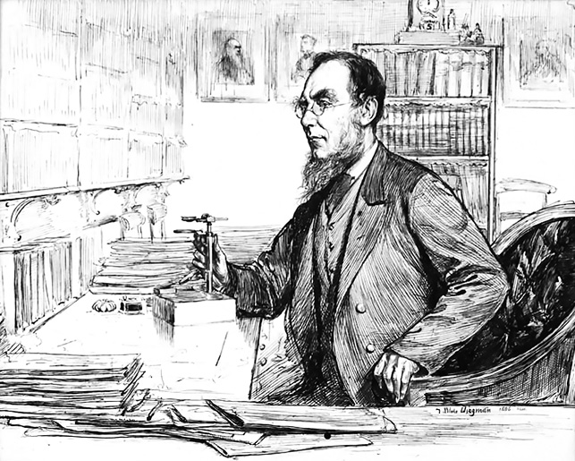
Figure 8.3. Joseph Hooker at work. Pen and ink drawing by Theodore Blake Wirgman, 1886.
Source: Courtesy of the Board of Trustees, Kew Gardens.
The historian Iain McCalman in Darwin’s Armada engagingly described Hooker’s role in encouraging Darwin to publish his views. In 1856 Darwin was becoming increasingly concerned about the need to publish his work. His long study of barnacles confirmed his status as a specialist biologist—a taxonomist familiar with the intricacies and overlap of natural species. Social circumstances in Britain might also have favoured the presentation of a challenging theory. There was a sense that Britain was becoming more prosperous in the mid-Victorian era in contrast to the poverty-driven instability that prevailed on his return on the Beagle. The implications of Darwin’s theory, with its potential to destabilise the religious foundations of the country, might be better received in this later more prosperous environment. Further, there was the hint that papers coming out of Sarawak by the young naturalist Alfred Wallace—although pre-dating Wallace’s grand theory—were being well received, carrying with them the possibility that Darwin’s ideas would lose priority.
McCalman described the genesis of a plan to encourage and to enable Darwin to publish his work. This involved a weekend of strategic planning at Down House, where Darwin was confined at home by a persistent illness. To this meeting, in April 1856, he invited those he knew to be ‘rising scientific stars’ whose opinions he could test. First among these, and an early arrival, was Joseph Hooker, whose botanical expertise would be a valuable asset. Then there was the biologist Thomas Huxley, newly elected to the Royal Society and recipient of its Gold Medal—the youngest person ever to receive that award. While others with a scientific or cultural interest were present, it was the small ‘lobby group’ of his close friends that he hoped to stimulate to reform British science, thought to have become conservative and moribund.
From what we know of this meeting it stimulated Darwin to feel sufficiently encouraged to announce to the geologist Charles Lyell that he had made the decision to write a book about natural selection. It was in June 1858 that the fateful—in Darwin’s eyes—letter from the ‘amateur’ naturalist Alfred Wallace arrived at Down House, with the implication that he, Darwin, had been forestalled in the presentation of his theory.
The eventual presentation of his theory to the public has been well documented, detailing how, after much agonising, an outline of Darwin’s thinking was delivered, together with Wallace’s letter, at a meeting of the Linnean Society in July 1858. Joseph Hooker, in partnership with Charles Lyell, was the mover and shaker in arranging the joint presentation of the two papers and their publication the following month. It was further pressure from Hooker that drove Darwin to write a formal abstract for publication by the Linnean Society journal. This quickly expanded to become On the Origin of Species by Means of Natural Selection. As McCalman describes, with reference to Joseph Hooker, Darwin was ‘buoyed unimaginably by support from Britain’s most talented and scrupulous botanist’.
I had my own encounter with Joseph Hooker, separated by 100 years, startling but nevertheless lively enough to bring the man to life, if only momentarily. In Australia’s National Library I had been reading the library’s copy of Leonard Huxley’s Life and Letters of Sir Joseph Dalton Hooker, when a small slip of paper bearing a letterhead fell out of the volume. At the top was printed ‘The Camp, Sunningdale’, with a date of May 1908. The Camp was the property purchased by Hooker in Berkshire, where he continued to work in his retirement.
Below the letterhead a spidery hand had penned a note thanking a family friend for sending the writer a shawl—a ‘wrapper’—for his birthday, with a compliment on the material. The shaky signature at the bottom was J.D. Hooker. The bookplate in the volume showed that it had been donated by one Richard Hannay Hooker, but I have no idea what that connection might reflect. I presented the volume, with its historic note from the then 94-year-old Joseph Hooker at a library desk, but it took some years for the value of the included note to be recognised; it has now been preserved, and the volume withdrawn from general circulation to become part of a special collection.
Previous Next