


 menu
menuRoars from the Mountain
3
World War and Australian Recovery
Pacific War and a Retreating Australia (1941–42)
Japanese military expansion in the Pacific reached a pivotal point on 7 December 1941 when aircraft attacked and bombed Pearl Harbour, Hawaii, triggering the entry of the United States into the Pacific War. The strong momentum of the Japanese advance southwards through East Asia continued, and the Japanese captured the Australian-held town of Rabaul, Territory of New Guinea, on 23 January 1942 (Wigmore 1957). Rabaul would be the stepping-off point for Japanese advances even further south, including overland towards Port Moresby (McCarthy 1959). The Australian Government and the Administration of the Territory of Papua therefore made preparations for further attacks. Australian civilian administration ceased in February 1942 in many parts of the Northern and North-Eastern divisions of Papua, leaving the Orokaiva to cope with the subsequent invasion of yet another dominating foreign power. The Australian war in the two territories would now be run from military headquarters in Port Moresby.
The Australian Military Intelligence Section soon began releasing ‘terrain studies’ of the South-West Pacific area. One of these geographic intelligence reports was for the northern coast and plains of the Northern Division of Papua. It contains the following bald descriptions of the still isolated and underdeveloped missions at Sangara and Isivita on the slopes of Mount Lamington (AGS 1942a, appendix G, gazetteer, 6, 10):
Sangara Mission. Consists of a group of houses, one European house with iron roof. All other houses, including church, of native material. Approx. 10 houses.
Isivita. 12 houses. Pop. 120 approx. Village and Mission Station. V.C. [village constable] and Cllr. [councillor] speak very little English.
Plantations listed in the terrain study included Sangara Rubber Estates, which was also called Mason’s, consisting of 300–400 acres of cleared ground planted with young rubber trees up to three years old, as well as government coffee plantations that were scattered throughout the Sangara district, 100 acres in all (AGS 1942a, appendix G). The coffee shrubs were about ‘man high’—that is, soldier high. There were also numerous, small, village-owned plantations, of both coconut and rubber, and each mostly less than an acre in extent. Four plantations in the vicinity of Sangara and Higatura are plotted in one of the accompanying maps (AGS 1942b). There is no mention of Mount Lamington being a volcano.
Missionaries were still stationed at Isivita and Sangara, and at Gona and Eroro on the coast. Bishop Strong on Saturday 31 January 1942 said in a radio message to mission staff:
As far as I know, you are all at your posts and I am very glad and thankful about this. I have from the first felt that we must endeavour to carry on our work in all circumstances no matter what the cost may ultimately be to any of us individually. God expects this of us … The Universal Church expects it. (Tomkins and Hughes 1969, 27)
Advances and Betrayals (1942–43)
The Japanese Army landed from naval troop carriers at Sanananda between Gona and Buna on the north coast of Papua on the night of 21–22 July 1942 (e.g. McCarthy 1959). They soon occupied nearby parts of the Northern Division that had been abandoned by the Australian civil administration in February, capturing any Europeans who were unfortunate enough to have stayed behind. Orokaiva villagers now had to choose which side ‘they felt offered the best opportunity for themselves and their families, keeping their own livelihoods safe while also serving the interests of their colonial masters’ (Grant 2014, 114)—that is, whether the newly arrived masters were the Japanese or the recently departed Australians.
European missionaries escaped into the bush from their missions at Sangara and Isivita but, together with others from Gona, were eventually handed over to the Japanese by some Orokaiva people (Tomlin 1951; Tomkins and Hughes 1969; Grahamslaw 1971b). Seven of the missionaries, with others, were executed at Buna. These included Reverend Henry Holland as well as Miss Lashmar and Nurse Brenchley who had written about their ascent of, and hearing the ‘roars’ from, Mount Lamington in 1935. They were beheaded by sword. Their remains were never found and were presumed to have been thrown into the waters of Dyke Acland Bay. Betrayal by the Orokaiva and execution of innocent civilians by the Japanese are key elements of the story that emerged subsequently, but so too was an opinion reached much later that the two executed mission priests—Reverend Holland and Reverend Vivian Redlich—had been murdered by the Orokaiva rather than by the Japanese (Hand 2002). Further, a young Papuan teacher and evangelist in training with the mission, Lucian Tapiedi, who was not Orokaiva, had been killed by an axe that was said to have been wielded not by a Japanese soldier but by an Orokaiva.
Japanese soldiers in their thousands soon swept westwards along the Yodda Road north of Mount Lamington, and then began their southwards land advance towards Port Moresby, along the tortuous footpath and deeply ravined terrain of the Kokoda Track. They were eventually repulsed by Allied forces, under the overall command of US General Douglas Macarthur, in fighting that has been made legendary through numerous military histories (e.g. Milner 1957; McCarthy 1959; Mayo 1974; Hall 1981; Paul 1989; Gailey 2000; Ham 2004; Fitzsimons 2004; Grant 2014). The Japanese were forced back along the Kododa Track and the Yodda Road to the north coast of New Guinea island. They became entrenched at Buna, Sanananda and Gona in a strong, well-designed complex of mutually supporting defensive positions and concealed by dense tropical vegetation, but were eventually defeated in January 1943 after attacks on different fronts (Figure 3.1). These attacks involved exceptionally bloody battles. The attacks also involved the creation of new jeep tracks and trails that extended the network of land links to the original Yodda Road north and east of Mount Lamington, which survived in the years immediately after the war. The Japanese in Papua as a whole inflicted more than 8,500 casualties on the Australian and American troops between July 1942 and January 1943, and themselves lost about 13,000 (McCarthy 1959). Lamington seems to have remained volcanically silent as a backdrop to this devastating warfare.

Figure 3.1. Paths of attack during the Buna–Gona campaign
This map of Allied troop movements north of Mount Lamington during World War II is adapted from the one published by Milner (1957, map 7, 127).
There was war in the air too, the presence of bombers and fighter aircraft necessarily involving construction of new airstrips in the Northern Division, built first by the Japanese and then in particular by the occupying Allies. One of these airstrips was constructed in mid-November 1943 at Popondetta by the American 2/6th Field Company using numerous Papuan labourers who cut a swathe through the kunai grass (McCarthy 1959). The airstrip was built quickly at the south-western end of a vehicular road that ran through to the coast (Figure 3.1). It permitted the aircraft landing of soldiers, field guns, jeeps and ammunition that were put to immediate use against the Japanese at the coast.
The Papuans of the Northern Division witnessed the mechanisation and destructive violence of the military conflicts between the invading foreigners. Many Orokaiva endured the consequences of war, including the military thefts of food from their subsistence gardens and enforced conscription. Some escaped into the bush where they suffered malnutrition and death (e.g. Waddell and Krinks 1968). Others served the Australians loyally, including those men who became members of the Papuan Infantry Battalion. Villagers also rescued Allied airmen shot down by the Japanese and helped return them to their operational bases.
Men from the villages were conscripted by both the Japanese and the Allies to serve as carriers, guides and labourers, and many were poorly treated. Some were stretcher bearers for injured soldiers or escorts for them (Figure 3.2). Many displayed considerable endurance and solicitude towards wounded Australians whom they carried to safety (e.g. Kokoda Initiative 2015). The grateful Australians gave them the well-meaning, and now legendary, sobriquet of ‘Fuzzy Wuzzy Angels’, which nevertheless still hints at the racial condescension that was part of even the best of wartime relations where they existed. Importantly, too, the war effort would result in a substantial increase in awareness in Australia of Papua and Papuans, not least recognition that the Allies may not have defeated the Japanese had it not been for the essential work undertaken by the ‘Fuzzy Wuzzy Angels’ even where they were under compulsion to do so (e.g. Grant 2014).
One piece of evidence that the Allies required the service and support of the Orokaiva, in particular, is seen in the following racist quotation warning Australian soldiers of the difficulties in crossing the swamp basins of the Northern Division: ‘It is probable that the local natives know and use a number of tracks across it, and where natives can lead, men on foot can follow’ (AGS 1942a, appendix F, 5)—a slip of the pen, perhaps, in which ‘men’ should have been written as ‘soldiers’. Racism and the need to exert white supremacy were rife, and young white Australian soldiers who came to Papua for the first time had to be reminded of their racial superiority, of the control structure that existed before the war and of the need to continue that colonial domination. Anthropologist F.E. Williams in 1942 wrote an instruction manual for the new soldiers entitled You and the Native, encouraging such an attitude of racial superiority (see, for example, Grant 2014). These prewar mores of white colonial society were strange to the newly arrived young soldiers who, in any case, made their own minds up about such views, particularly if they experienced firsthand the compassion of the ‘Fuzzy Wuzzies’ as stretcher bearers.
The Australian Army’s Australian New Guinea Administrative Unit (ANGAU) played a central role in the Allied war effort in the territories of both Papua and New Guinea (e.g. Mair 1948; Grahamslaw 1971a, 1971b, 1971c; Downs 1980; Grant 2014). ANGAU officers were mainly prewar government men such as resident magistrates, district officers, patrol officers and other officials—F.E. Williams, for example, became an ANGAU officer. There were, according to one ex-ANGAU officer:
Delicate problems of seniority and of difference of philosophy between former Papuan and former Mandated Territory officials … the petty animosities of small closed communities survived and smouldered in war as in peace. (Ryan 1973, 315–16; see also Ryan 1968)
Further, ANGAU officers had no, or very little, expertise in specialist fields such as agriculture and education—nor in anthropology, following the death of government anthropologist F.E. Williams in an aircraft crash in 1943. One of ANGAU’s primary roles in 1942 during the Papuan campaigns was to recruit from Orokaiva the males required as carriers, stretcher bearers, labourers and guides. This was undertaken aggressively at times, on occasions leaving villages bereft of men. ANGAU’s most important role in 1943 was the reinstatement of Australian authority, civil administration and local development in areas no longer occupied by the Japanese. Duties at this time also included the arrest of those Papuans who had abandoned their allegiance to the Australians and who were accused of betraying or murdering Europeans during the Japanese occupation.
In December 1942, ANGAU Officer Captain Thomas Grahamslaw was instructed by headquarters to resume duty as a civilian district officer in the Lamington area of the Mambare District, which by then had been deserted by the Japanese (see, for example, Fitzsimons 2004; Grahamslaw 1971c). His suggestion that Higaturu—just south of where the Sangara Mission had operated before the war—would be a suitable place for the temporary district headquarters was accepted by those in authority in Port Moresby. New administration offices at Higaturu were constructed. ANGAU staff also restored the Sangara coffee plantation and machinery that had been damaged by the Japanese (Mair 1948). The Higaturu headquarters soon became permanent, thus representing a shift from the former government administrative centre at Buna and its steamy coastal climate, to the more pleasant air of the cooler mountains. Higaturu and Sangara, however, are only about 10–11 kilometres from the summit area of Mount Lamington.
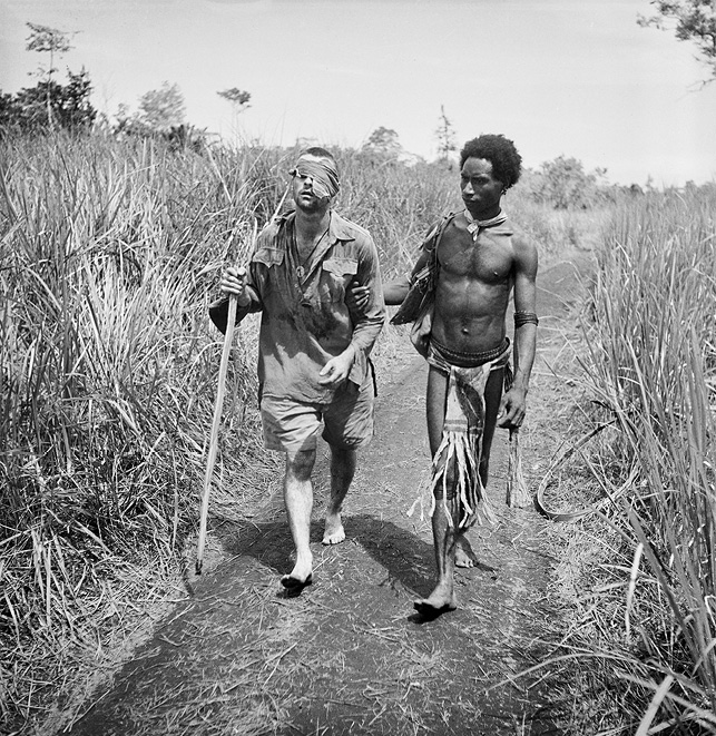
Figure 3.2. George Silk photograph of Raphael Oimbari and Private Whittington
Wartime official photographer George Silk took what has become a famous photograph—reproduced in many war histories—of a young Orokaiva man escorting a wounded Australian soldier, Private G.C. Whittington, near kunai at the Old Strip, Buna, on Christmas Day 1942. Raphael Oimbari, the Orokaiva escort, was not identified and named from the photograph until the 1970s (Grant 2014). Whittington later died of his wounds. Photograph supplied courtesy of the Australian War Memorial (reference number AWM14028).
Chief Justice of Queensland Sir William Webb was appointed in 1943 to lead a Commission of Enquiry into wartime atrocities that affected Australians (e.g. Redlich 2012). The enquiry, which took place after the Japanese defeat at Buna in January 1943 but before resumption of full civil authority in the Lamington district, determined the cases of eight of those murdered by the Japanese in the Sangara–Popondetta area, including four female missionaries. The killings were determined to be ‘atrocities’ and to have been undertaken, in the case of the women and a child, with ‘fiendish brutality’ (quoted in Redlich 2012, appendix 5, 146).
The trials of Papuans who were accused betrayers and Japanese sympathisers were held at Higaturu. ANGAU Officer Captain W.R. ‘Dickie’ Humphries, a former resident magistrate, conducted the proceedings, or at least most of them (e.g. Palmer 1992; see also Pacific Islands Monthly 1951a). The subsequent public hangings of five Papuans from tree branches, followed by 17 more, also took place in the Higaturu area (Grahamslaw 1971c; Nelson 1978; Newton 1985; Bashkow 2006; Grant 2014; Stead 2018). Gallows were specially constructed for the 17 condemned men who were hung two at a time from early in the morning until late in the afternoon in front of thousands of local people. Those hung were civilians and should have been judged by Australian civil law and not by the military, but the army at the time appears to have had a strong desire to re-establish and exert Australian authority. The retributive hangings ensured the maximum controlling impact possible, even though the Australian Cabinet in Canberra evidently did not become aware of them, and of other hangings, until well after the events took place.
American forces in their thousands were stationed at this time in the Oro Bay and Dobodura area, although they were dissuaded from attending the hangings (Grahamslaw 1971c). A major military port was developed by the Americans at Oro Bay as a forward Allied base and an inland road system sprang up for the machinery and materials needed for construction of the airfields at the great Doboduru air base (McCarthy 1959). Buna was later developed by the Australians as a military port for build-up of the supplies needed for Allied attacks on the Huon Peninsula to the north, which was made possible by aircraft flying out of Dobodura and by heavy bombers flying from Port Moresby.
Both American and Australian troops in the Northern Division could be generous towards the Orokaiva, sharing cigarettes and gifting them tobacco, food, clothing, tools and so forth (Figure 3.3). The Americans, in particular, ate and fraternised with the Orokaiva locals who concluded that some of the Americans must be ‘returned ancestors’ (e.g. Schwimmer 1969). Some of the US soldiers deployed to the New Guinea theatre of war were ‘coloured’ African-Americans who, although they experienced racial antipathy during their military service (e.g. Hall 1995; Bashkow 2006), were seen by the Orokaiva and others as wearing the same clothing, eating the same food, occupying the same housing and working in tandem with their white-skinned compatriots.
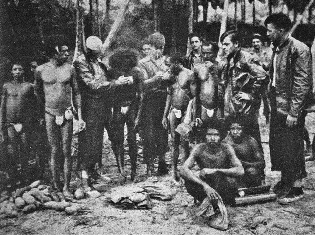
Figure 3.3. ‘Fuzzy Wuzzy Angels’ and American sailors sharing cigarettes
American sailors share cigarettes with Papuan carriers in this WWII photograph reproduced from an article by Porter (1951c, 7) in which it was attributed to the ‘Wide World’.
The Orokaiva witnessed the vast resources that the foreign troops deployed and controlled, and saw technical achievements being displayed on a colossal scale. They were being presented, probably for the first time, with good reasons for looking at the outside world, and those who governed them, in a new light. Indeed, the few years of the 1942–45 foreign war may have had a more enduring impact on them, and their landscape, than the much longer period of prewar colonial administration by the British and the Australians (e.g. Moss 2017). Old Orokaiva ways, or iji matu, were disappearing and a ‘new day’ or iji eha would develop and be influenced within a few years not only by a strong postwar expansion of Australian interest in Papua as a whole (e.g. Legge 1956), but also by the impact on the Orokaiva of the eruption at Lamington volcano (e.g. Schwimmer 1969, 62, 70). Meanwhile, a quite different volcanic eruption well to the south-east of Lamington was receiving some attention at the end of 1943.
Goropu Eruption and New Geological Mapping (1943–44)
An ANGAU unit including Lieutenant David Marsh was active in north-eastern Papua in 1943 and was based at Tufi at the northern end of the Cape Nelson peninsula. Its members patrolled the coastline of Collingwood Bay, including the Wanigela area to the south where the Reverend Dennis Taylor was based at the Anglican mission. Taylor had joined the mission at Dogura in 1937 but soon transferred to Wanigela where he stayed throughout the war. In 1942, his wife and child, and other European women, were led by him to safety on foot southwards over the arduous Owen Stanley Mountains, but Taylor immediately returned to the Wanigela area, near Mount Victory, where he resumed his mission duties (Tomkins and Hughes 1969).
An unexpected volcanic eruption surprised people living on the Cape Nelson peninsula when four columns of ‘smoke’ and ash were seen by coastal villagers in October 1943 in the hills south of Victory volcano, as well as other unexpected clouds in November (NAA 1943–45; Marsh 1944; Baker 1946; see also Johnson 2013, for a general review of the eruption). Earthquakes had been felt in the Tufi area during the previous two years. The ‘smoke’ in the hills south of Tufi was from new volcanic vents in a gently sloping area known locally as Waiowa at the northern foot of the Goropu Mountains in the Owen Stanley Range alongside a major geological fault, where eruptions had never been reported previously and where no volcano was known to exist (see Figure 0.2).
A much larger eruption took place on 27 December 1943, producing a 5,000-metre-high cloud of volcanic ash that caused great concern at Wanigela on the coast to the north-north-east. Reverend Taylor reported that:
People were screaming and running in all directions and kids and babies were crying and wailing, [and] the place was in a panic … It was a most awe inspiring sight to see this great mass of smoke, a greyish orange and purple colour just billowing overheard [sic] and sort of rolling over itself and accompanied by the sound of the roar of hundreds of mighty furnaces. No wonder the people were frighted [sic]. Jack and I were scarred [sic] stiff. (Taylor 1943, 1)
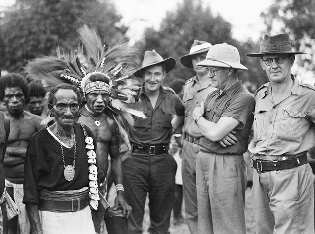
Figure 3.4. Minister Ward and Colonel Conlon at Higaturu in 1944
Australian Minister for External Territories E.J. Ward (second from the right wearing a solar topee) and his adviser, Colonel Alf Conlon (on the right), meet Orokaiva men at Higaturu in April 1944. Photograph supplied courtesy of the Australian War Memorial (reference number AWM 072668).
There were additional eruptions on 13 February and 23 July 1944 and a fourth and final one is thought to have taken place on 31 August. However, the exact number of eruptions during the entire eruptive period, and any significant differences between them, are unknown because no systematic visual observations were made and the eruptions were not studied at the time by either volcanologists or geologists. Lieutenant Marsh, however, visited the area during its activity, taking photographs and reporting his observations of the volcanic blast effects on the destroyed forest surrounding the craters (Marsh 1944, 2005–08).
In 1944, Dennis Taylor and his family were transferred from Wanigela to Sangara to re-establish the work of the Anglican mission (Strong 1951; White 1991). Higaturu and Sangara were now becoming established as twin settlements for the representatives of both State and Church in the district on the flanks of Mount Lamington. There was even a visit to Higaturu by Australia’s minister for external territories E.J. Ward. Ward and his adviser Colonel A. Conlon visited Higaturu in April 1944 (Figure 3.4). Head of the army’s Directorate of Research and Civil Affairs, Conlon was principally a headquarters adviser on Australian transitional policy in the two territories for General Sir Thomas Blamey, the commander-in-chief of the Australian Army (Sligo 2013). Although a rather controversial figure, Conlon nevertheless emerged as a skilled adviser with the ability to relate to men in power, and the directorate was influential in what today would be called ‘post-conflict operations’—that is, management and implementation of military government policy and civil affairs. He also ‘had a genius for recruiting talent’ to his directorate, whether scholars, lawyers, public servants, poets, anthropologists or scientists (Sligo 2013, viii). One such scientist was the oil company geologist Martin F. Glaessner who was chief palaeontologist for the Australian Petroleum Company and who, during the war, undertook volunteer work for the directorate.
In 1944, the directorate published a ‘Geological Sketch Map of Eastern New Guinea’, together with set of explanatory notes produced by three oil company geologists including Glaessner (Montgomery, Osbourne and Glaessner 1944). The map was based on extant geological information and included data collected by the Australasian Petroleum Company, and other companies, over a period of many years (see, for example, Anglo-Persian Oil Company 1930). Goropu was identified on the map as an ‘active volcano’ as a result of its inaugural 1943–44 eruptions. Another feature is that the extent of the area shown for Mount Lamington and the Hydrographers Range is different to the one mapped by Stanley (1924). The three geologists, however, again restricted the age of the volcanic rocks to the Pleistocene and did not distinguish any difference in geological age between Lamington and the Hydrographers (Figure 3.5). How the area of volcanic rocks came to be remapped is unknown, but, speculatively, wartime aerial photographs may have been available to the geologists for additional geological interpretation of an area where there had been heavy fighting.
The bibliography in the report published by Montgomery, Osbourne and Glaessner (1944) includes the geodynamics paper published by van Bemmelen (1939), but they did not refer to his brief claim of Mount Lamington being an ‘active volcano’. Nor did they revise this omission in two further papers published six years later (Montgomery, Glaessner and Osbourne 1950; Glaessner 1950; see also David 1950). The reason for the omission is unknown, but possibly they had doubts about the veracity of the claim. Many years later, van Bemmelen could not recall from where he obtained his information about Lamington being an active volcano (van Bemmelen 1982). He thought it might have been from his colleague Dr C.E. Stehn, director of the Netherlands Indies Volcanological Survey, who had undertaken investigations in Rabaul after the 1937 eruption. However, according to Dr N.H. Fisher, who worked with Stehn in Rabaul and who later (in 1939) visited Java to undertake volcanological training from Stehn, this too seems unlikely. Fisher said that Stehn did not mention anything to him about Lamington being an active volcano (van Bemmelen 1982).
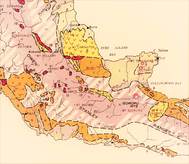
Figure 3.5. Detail from geological map by Montgomery, Osbourne and Glaessner
The distance across this part of the geological map by Montgomery, Osbourne and Glaessner (1944) is about 270 kilometres. North is to the top. The ‘v’ pattern on a yellow background and numbered ‘6’ represents ‘Pleistocene volcanic deposits’. The open circles represent the ‘dormant and extinct’ volcanoes of mounts Victory and Trafalgar, and the double concentric circles represent ‘active volcanoes’—Goropu is the only one so identified. Mount Dayman is shown as a volcano, but this is an error that stems back to the work of A.G. Maitland (1892a, 1892b).
Territory Administration and the Bureau of Mineral Resources, Geology and Geophysics (1945–50)
The Allies advanced into the Territory of New Guinea after the Buna–Gona battles, gradually overcoming the Japanese presence. The Japanese had built a defensive complex of caves and tunnels in the volcanic deposits at their naval headquarters at Rabaul and they were contained by regular aerial bombing while Allied troops moved north to the Philippines and Okinawa (Dexter 1961; Long 1973). The final battles of the European theatre of World War II (WWII), including the German surrender to the Soviet Union and the Western Allies, took place in late April and early May 1945. Japan signed the surrender on 15 August 1945—V-J Day—just days after the disastrous atomic bombings at Hiroshima and Nagasaki on 6 and 9 August. Photographs of the lateral blasting of the buildings and infrastructure of both cities were terrifying images of the power of atomic energy and what would happen if ever it was used again in warfare. The struggle for supremacy in the Atomic Age between the US and the Soviet Union also began in 1945, and Australia again aligned itself with the US and its anti-Communist politics.
The concept of a decolonising British Empire was evolving resolutely by 1945 towards a new Commonwealth of Nations that encapsulated increased self-governance of former British territories. The old colonies would now be treated as free and equal member states. Further, the United Nations (UN) had been created in 1945, replacing the ineffective League of Nations. These global trends were reflected in a policy speech made by Minister Ward in July 1945 to the Australian Parliament in Canberra, the month that Labor Prime Minister John Curtin died and his position was taken over by J.B. Chifley. Postwar events were changing significantly in the two territories of Papua and New Guinea:
The Government is not satisfied that sufficient interest had been taken in the territories prior to the Japanese invasion, or that adequate funds had been provided for their development and the advancement of the native inhabitants. Apart from the debt of gratitude that the people of Australia owe to the natives of the territory, the Government regards it as its bounden duty to further to the utmost the advancement of the natives, and considers that that can be achieved only by providing facilities for better health, better education, and for a greater participation by the natives in the wealth of their country and eventually in its government. (Mair 1948, 207–08, quoting from Commonwealth Hansard 1945, 4050–55)
A provisional government was foreshadowed by Ward for the two former territories of New Guinea and Papua. There would be only one administration, which was the arrangement that ANGAU had used during the war. The new UN Trusteeship of the Territory of Papua and New Guinea (TPNG) was, therefore, an administrative union between the former Territory of Papua, which had been a possession of the Crown, and the Territory of New Guinea, a Mandated Trust Territory (Papua 1945a; New Guinea 1945; Hasluck 1976; Downs 1980). There would also now be a single administrator based in Port Moresby but accountable to the Australian Government in Canberra. This arrangement was for some years a union only in theory until it became established in Commonwealth of Australia law in July 1949.
The different Australian administration officers, or kiaps, who had worked in the separate administrations before the war now had to adjust to the new structure and responsibilities created after it. Officers were called district officers, assistant district officers and patrol officers, as they had been before the war in the Mandated Territory. The Papuan title of resident magistrate created under Hubert Murray was abandoned, and the title district officer would soon change to district commissioner. ANGAU had demonstrated that the two territories could be managed as a single entity in wartime conditions and despite the internal competition or even animosities between the prewar ‘New Guinea’ and ‘Papua’ officers. Many of those same officers now had to collaborate and cooperate in managing the new Trust Territory as a whole and to communicate across the old boundary between the two former territories. This included the two-way link between Port Moresby, the new capital, and distant Rabaul, the former capital of the old Mandated Territory.
Colonel John Keith Murray was appointed as the new TPNG administrator by the Australian Government in October 1945, following in the tradition of the colonial vice-regal and pro-consul style of administrator established by William MacGregor and Hubert Murray (e.g. Mair 1948; Downs 1980; Sligo 2013). Colonel Murray had been foundation professor of agriculture at the University of Queensland, a member of Conlon’s Directorate of Research and then chief instructor at the army’s School of Civil Affairs in Canberra. He was a strong supporter of Ward’s policy and became administrator at a critical and difficult time when Australia was attempting to implement its new postwar policies for the combined former territories. This work was in the face of opposition from influential people both in Port Moresby and Canberra, some of whom thought the ex-military man was not sufficiently reliant on Canberra politicians and public servants (Hasluck 1976). Perhaps, too, his habit of conducting his ceremonial duties dressed in full ‘vice-regal’ uniform conveyed too much of the flair of an old-style British governor. Other critics were sardonic towards Murray, calling him ‘Kanaka Jack’ because of his favourable practices towards local people, although others used the appellation with genuine affection (Nelson 1982, 176). Murray, in any case, was well respected for his hard work, practicality, uncompromising integrity and scientific appreciation of issues. Bishop Phillip Strong at Dogura, for example, was one of Murray’s strong supporters. Murray stayed as administrator for more than two years after the defeat in December 1949 of the Australian Labor Party who had appointed him. The new government in Canberra was a coalition of the Liberals and Country Party under Prime Minister Robert G. Menzies.
The TPNG administration’s postwar headquarters for the Northern Division were at Higaturu, adjacent to the reoccupied Sangara Mission and about 10 kilometres from the summit of Lamington. About 4,000 Sangara people, most of whom were still dependent on subsistence agriculture, were thought to live in the surrounding area in villages and hamlets. Higaturu itself was accessed by a short connecting track south-east from the principal road between Popondetta and Wairopi and running westwards to Kokoda. By 1950, the Northern Division was under the control of District Commissioner Cecil Cowley, whose headquarters were in a simply constructed, single-storey building alongside an assembly area where the Australian flag could be flown on special occasions (Figure 3.6). There was also, by this time, a post office, hospital, doctor, staff accommodation, Department of Works and Housing support, technical training centre, police barracks, parade ground and gaol. Higaturu had radio communication with Port Moresby and with other stations. The nearest airstrip was at Popondetta about 10 kilometres to the north-east and about 21 kilometres from the summit area of Mount Lamington. Mail could now be sent out from Popondetta by small aircraft (Figure 3.7). This was quite unlike the government postal service before the war when a police runner carried mail to Kokoda and exchanged his mail package with a counterpart runner from Port Moresby, each runner then returning to his point of origin.
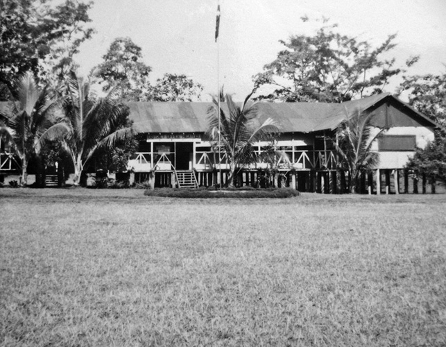
Figure 3.6. District headquarters at Higaturu
This photograph of district headquarters at Higaturu and the parade ground in front of it was taken by Kevin Woiwod. It was provided courtesy of the Woiwod family.
Agricultural development by the administration was re-established in the Northern Division by staff of the Department of Agriculture, Stock and Fisheries (e.g. Godbold 2010). The European agricultural extension officers, or didiman, by 1950 were F. ‘Fred’ Kleckham and Grainger ‘Blue’ Morris. They lived with their families in simple staff quarters in the small and undeveloped cluster of housing at Popondetta where Jack Scurrah also ran a trade store for Buntings Pty Ltd. The agricultural officers created an experimental station near Popondetta for the testing and development of new types of crops in the district. The large, company-owned Sangara Rubber Plantation was to the south-west along the main road past Double Crossing on the Ambogo River, and was managed by European staff. Awala Plantation was further west along the road and was owned and run by the Searle family.
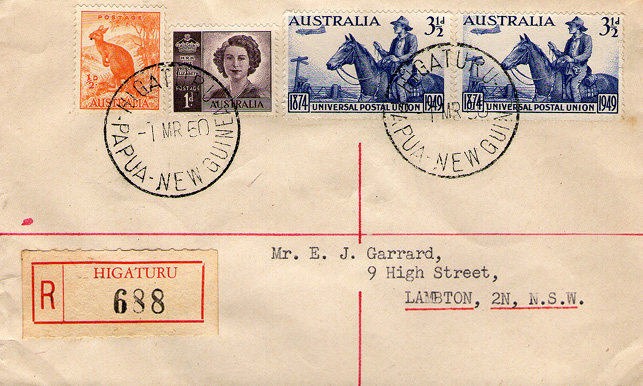
Figure 3.7. Higaturu postmarked envelope franked on 1 March 1950
This is a rare copy of a Higaturu postmarked and registered envelope using Australian postage stamps and franked on 1 March 1950. Princess Elizabeth, who became Queen Elizabeth II in 1952, is shown in the second stamp from the left (between the kangaroo and the horseman). This image of the envelope was provided courtesy of Munro Kennedy and Max Hayes.
No geologists came to Sangara–Higaturu after the war and before 1951, but they did come eventually to the new TPNG. An Australian national geological survey, the Bureau of Mineral Resources, Geology and Geophysics (BMR), was created in 1946 for an ambitious program of systematically mapping the geology of the Australian continent, including TPNG (Wilkinson 1996). Recruitment of suitably trained staff to BMR was difficult, however, until new postwar graduates started to become available from the universities. An oil company geologist, A.K.M. Edwards, was eventually appointed resident geologist in Port Moresby in 1949 when a geological office was established there.
BMR also had the responsibility of re-establishing volcanological services in the new Territory, but the volcanological observatory at Rabaul did not become operational again until after G.A.M. ‘Tony’ Taylor arrived there in April 1950 (Fisher 1976). Taylor’s volcanological responsibilities now covered the whole of the new Territory and not just the Mandated Territory of New Guinea, as his predecessors had in prewar times. His priority was to establish instrumental monitoring of Rabaul volcano, but in December 1950 he also inspected Bagana volcano after some particular powerful explosions earlier that year (Taylor 1956).
Return of the Anglican Mission (1945–50)
Re-establishment of the Anglican mission stations at Sangara, Gona, Isivita and Eroro had also been taking place (Tomlin 1951; White 1991; Tomkins and Hughes 1969; Hand 2002). An early task was disinterring the remains of three of the Anglican mission workers who had been murdered during the war, and reburying them at Sangara thus establishing the Martyrs Cemetery. The three ‘martyrs’ were Mavis Parkinson, a teacher at Gona Mission; Sister May Hayman, a nurse at Gona; and Lucian Tapiedi, a young Papuan teacher from Milne Bay whose statue can be seen today in London at Westminster Cathedral (Hand 2002).
Reverend Dennis Taylor worked from 1944 onwards rebuilding the Sangara and Isivita stations (Strong 1951, 1981). This included the repair and reconstruction of St James Church and a schoolroom at Sangara. Taylor ‘was a man of few words, but immense resource and ability … an experienced bushman [who] had a great capacity for organising, improvising and getting things done’ (White 1991, 6). His wife Lesley, a mission teacher, returned in 1945 and became involved increasingly in raising their growing family of four children. Dennis Taylor was assisted at Sangara by Reverend John Rautamara, a Wedauan from the Dogura area whose father, Peter, in 1917 had been the first Papuan to be ordained as an Anglican priest. John Rautamara ‘was a big man in every way, physically, intellectually, and spiritually [and] was a splendid athlete’ (Hand 2002, 35). He was also an inspirational preacher who seemed to have had a special affinity and vocation for the Orokaiva (e.g. Tomkins and Hughes 1969).
Margaret or ‘Peggy’ de Bibra was a well-qualified teacher who arrived at Sangara in 1947. Her task was to re-establish mission education including—and initially by herself—a secondary school that was later named the Martyrs Memorial School. Miss de Bibra came from a distinguished Tasmanian family, was a first-class honours graduate from the University of Melbourne and had given up a position as headmistress of an Australian high school to become a missionary teacher at Sangara. She was joined in 1948 by another trained teacher, Nancy White, who took over duties in the primary school allowing de Bibra to concentrate on the secondary school (White 1991).
Reverend David Hand arrived at Sangara from Dogura in 1948 as acting priest-in-charge while Dennis Taylor and his family went on furlough. This was Taylor’s first long break from mission work since 1937. Hand was met at Sangara by John Rautamara and Peggy de Bibra who soon became his close colleagues and friends. Hand was born in Australia but raised in England where his father, Canon W.T. Hand, was also an Anglican churchman. David Hand developed a strong commitment to Christian evangelism among the Orokaiva and especially the Sangara people. He took his guardianship responsibilities seriously, developing a fatherly concern and deep affection for the Orokaiva. Hand also seems to have had a forceful, commanding, even formidable personality and, where necessary, could use his ‘stentorian voice’ (White 1991, 20) to good effect. Both Peggy de Bibra and David Hand became godparents to one of the Taylors’ children. Hand admired Miss de Bibra greatly and had considered proposing marriage to her (Hand 2002).
Several other Anglican missionaries arrived at the mission stations of Sangara, Isivita, Gona and Eroro in the postwar years up to the end of 1950. L.J. ‘Rodd’ Hart and teacher Miss Madeleine ‘Maddy’ Swan came separately to Sangara, and became engaged to be married. Reverend Robert G. Porter, Sister Pat M. Durdin and Mrs Barbara Lane were based at Isivita. Canon James Benson returned to Gona Mission after surviving three years as a Japanese prisoner of war at Rabaul (e.g. Chynoweth n.d.). He was joined by Reverend W.A. ‘Alf’ Clint, Sister Nancy A. Elliot and schoolteacher Elsie Manley. Sister Jean Henderson in January 1946 went as a nurse to Eroro Mission near the coast and just inland from the deserted American base at Oro Bay (Figure 3.1). She helped to build a hospital using bush materials and the concrete base of an old American bakery (Henderson 2007). Dr Blanche Biggs joined the Eroro staff in 1948, the first of a 27-year period of service in the area (Kettle 1979). The priest-in-charge at Eroro was Reverend J. Luscombe Newman, but he and his family went on leave and the relieving priest in January 1951 was Reverend John Andersen (Henderson 2007).
Relationships between the Anglican mission and administration were not particularly smooth. The activities of both agencies among the Orokaiva were not well coordinated, meaning that consistent development policies were made difficult (e.g. Waddell and Krinks 1968) and, presumably, some confusion was created in the minds of the Orokaiva. One example of a difference of opinion was in the area of secondary education. The mission believed that what the administration and European business community wanted ‘were clerks, interpreters, store-boys [and] “boss-boys” … to assist the smooth running of the white man’s administrative or money-making machines’ (Tomkins and Hughes 1969, 81). The mission, and Reverend Hand in particular, strongly articulated the view that secondary education for Papuans should take a more enlightened approach, embracing a future in which responsible government of the country may include the Papuans themselves. Two Anglican historians later asked the question of whether Hand and the mission had, in ‘those years of intensive white exploitation, 1947–51, a clearer idea of the future needs of a people, almost entirely living by subsistence agriculture in small villages, than did the government of Australia or the traders’ (Tomkins and Hughes 1969, 82). Such were the kinds of pressures, from both sides of this particular argument, that Administrator J.K. Murray had to manage at the time.
Another related example of such conflicts swirled around the mission-inspired Christian Co-operative Movement at Gona Mission, which was started by Canon Benson and implemented by Reverend Clint (Benson 1949a, 1949b, 1949c; Tomlin 1951; Tomkins and Hughes 1969; Garland 2000; see also Crocombe 1964; Dakeyne 1966; Waddell and Krinks 1968; Horne 2017). There was an emphasis on the cooperative growing of cash crops including, especially, rice in specially prepared fields. The administration had been encouraging secular cooperative movements elsewhere in the Territory because they were community-inspired, unlike before the war when compulsion was applied (e.g. Legge 1956). These secular cooperatives involved people from different villages tending common cash-producing crops but not necessarily involving concurrent work. The Christian Co-operative Movement was different, however, because the work was communal—that is, people working together at the same time—and because of its accompanying religious ceremonies that included prayers in the fields and gardens, ceremonial blessings by the bishop and tools being treated with particular reverence.
The Anglican-based movement spread effectively to other parts of Northern Division and began to generate large sums of money. The administration became concerned about these developments, as well as the perceived cargo cult–like character of the movement. These were also Cold War times, and there were additional concerns about the actual meaning of ‘cooperatives’ and their relationship to communism. Were they Christian ‘communes’ in the communist sense, despite their non-atheistic nature? Reverend Clint had left-wing ideological connections, and had been associated with the Christian Socialist Movement in Australia. The administration appointed cooperatives officers and took over the running of the Northern Division cooperatives, thus reducing the influence of the mission. Clint fell ill in 1949 and left for Australia, resuming his cooperatives work there with Aboriginal groups (e.g. Cunningham 1974).
Canon Benson also opposed a postwar pilot scheme for Australian soldier settlement on lands in the Sangara area. He argued that ‘the Papuan Infantry Battalion [also] had fought and died to save Australia, etc. All right then I say, Let the Papua Infantry Battalion boys go and take up land in Australia’, and told villagers that ‘whatever government or white man comes here don’t sell your land. Do not sell your land!!’ (quoted in Tomkins and Hughes 1969, 105). Senior members of the mission such as Benson and Hand therefore took seriously their responsibilities as the caring shepherds of their Orokaiva flocks, as one might expect from such committed missionaries in these difficult years of uncertainty and rapid external change.
David Hand was on a clear path of promotion in the Church of England hierarchy when, on St Peter’s Day 1950, at the age of only 32, he was consecrated as diocesan coadjutor (i.e. assistant) bishop to Phillip Strong at Dogura Cathedral. A striking, all-male ‘end-of-Empire’ photograph was taken of the event outside St Peter and St Paul Cathedral on 29 June—the old British Empire in Papua captured in an instant (Figure 3.8). The whole event was a memorable day for the young bishop who was photographed with five other mitre-wearing bishops. The ceremony also included some less than serious moments that Hand himself recorded, somewhat teasingly, at the expense of the administration and the justice system (see Hand 2002, 40–43). Helmeted Colonel J.K. Murray was in the full attire of administrator for the theatre of the day, wearing also a ceremonial sword that, in the highly charged atmosphere of the occasion, he forgot to unbuckle before entering the cathedral. His Honour Justice Ralph T. Gore was attending the ceremony as chancellor of the Diocese of New Guinea. He wore his full-bottomed judge’s wig, which he had to lift at times to mop his perspiring bald head because of the tropical heat. Judge Gore, Administrator Murray and Bishop Hand would, together with others in the photograph, play much more serious roles in the aftermath of the 21 January disaster at Mount Lamington.

Figure 3.8. Consecration of Bishop David Hand at Dogura
Bishop David Hand’s consecration was held at Dogura Cathedral on Thursday 29 June 1950, St Peter’s Day. This image is reproduced from the photograph published by White (1991, 38). Bishop Strong and Administrator J.K. Murray are facing each other in conversation left of centre in the front row; Bishop Hand is third from the right in the front row; Justice Ralph Gore is at the right-hand end of the same row; Ivan Champion is in the back row, first on the right from the left-hand candlestick; and Archdeacon Romney Gill is in the middle of the photograph, behind and just to the right of Administrator Murray. All of these named European men were involved seven months later in the 1951 disaster relief and recovery at Mount Lamington. The two Papuan priests carrying the processional candle sticks are Reverend Peter Rautamara (looking at the camera between Strong and Murray) and his son Reverend John Rautamara (looking to his left) who died at Sangara during the 1951 eruption. The names of all those shown on the photograph are listed by Wetherell (1977, fig. 30). The photograph is reproduced here courtesy of the Anglican Board of Mission, Australia.
Discovery of Volcano-Related Information from 1947–48
Europeans who lived in and visited the Higaturu–Sangara area commented on its impressive scenic setting: the great blue mountains of the Owen Stanley Range to the south and multi-peaked Mount Lamington in front of them. The schoolteacher, Miss de Bibra, for example, wrote that Lamington:
Lies behind us and consists of four or five sugar-loaf peaks [that, at times, are shrouded] in gossamer scarves of mist … We have always loved her for her beauty and nearness. (White 1991, 45–46)
Other people using non-prose referred to the peaks as ‘the Marx Brothers’, naming them after the popular American vaudeville team who appeared on radio and in films (e.g. South Pacific Post 1951a). Lamington, however, despite its natural features, was still not yet recognised as an active and threatening volcano.
There was no opportunity for any geologist or volcanologist to inspect Mount Lamington in the immediate postwar years, but aerial photographs were taken over the area in 1947–48 and any qualified geoscientist would have interpreted the youthful volcanic nature of the mountain by inspecting them. Volcanologist Tony Taylor, in particular, later pointed out features that were consistent with Lamington being a geologically youthful volcano, unlike those of the older Hydrographers Range to the east (Taylor 1958). Young lava flows were identified clustered around the summit of the mountain (Figure 3.9). These lavas, when extruded, had not been fluid or voluminous enough to flow very far but, rather, had accumulated as bulbous ‘lava domes’ and short stubby flows known technically as ‘coulées’.
Another important feature that can be identified on the aerial photographs of Mount Lamington is a summit volcanic crater. This was not a complete crater or ‘hole’ in the normal sense of the word but, rather, was an amphitheatre-like depression that faced towards the north. The amphitheatre-shaped headwall was drained by the north-flowing Ambogo River in the west, and in the east by the Banguho River that drained more towards the north-east. Both rivers flowed across the broad, populated, piedmont area that slopes away from the summit. The headwall of the amphitheatre must have been enlarged by erosion caused by these rivers and their upper streams, and by rock avalanches from the headwall. The debris was then transported by the rivers down what Taylor (1958, 7) referred to, appropriately, as ‘the avalanche valley’.
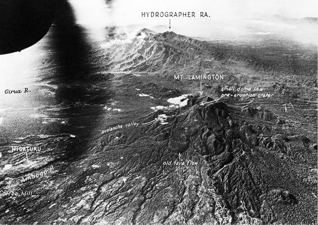
Figure 3.9. Military aerial photograph of the summit of Mount Lamington in 1947
This oblique aerial photograph of the summit of Mount Lamington, together with the Hydrographers Range in the background, was taken towards the east in 1947 by the US Air Force as part of a trimetrogon series of photographs distributed by the US Army Map Service (Taylor 1958, fig. 2). The labelling in white was added by Taylor. Buildings at Higaturu can be seen on the extreme left. Note also the Ambogo ‘avalanche valley’, the small summit crater containing a small lava dome or ‘tholoid’, and youthful lava flows and lava domes clustered south-west of and around the summit. Photograph supplied courtesy of Geoscience Australia (negative number G/3342).
Many volcanoes have avalanche amphitheatres. They are created where large slabs or sections of a volcano disintegrate and slide away from the summit of a volcanic cone, at times catastrophically, like giant landslides. Some of the depressions so formed are described as ‘horseshoe-shaped’—that is, open at one end. The headwalls are indeed generally curved, but the two walls that trend downslope can be quite straight, in some cases diverging from each other, but gradually reducing in height away from the volcano. An excellent example is found at Galunggung volcano, Java, which was mapped by a geologist of the Netherlands Indies in the 1920s (Escher 1925; see also Siebert 1984, fig. 1). A particularly striking feature of this Javanese example is the large area of hummocky topography downslope and south-east from the avalanche amphitheatre (Figure 3.10). These are volcanic ‘debris-avalanche deposits’ created by the disintegration of the volcanic cone, their gravitational transport downslope and redeposition at the foot of the volcano.
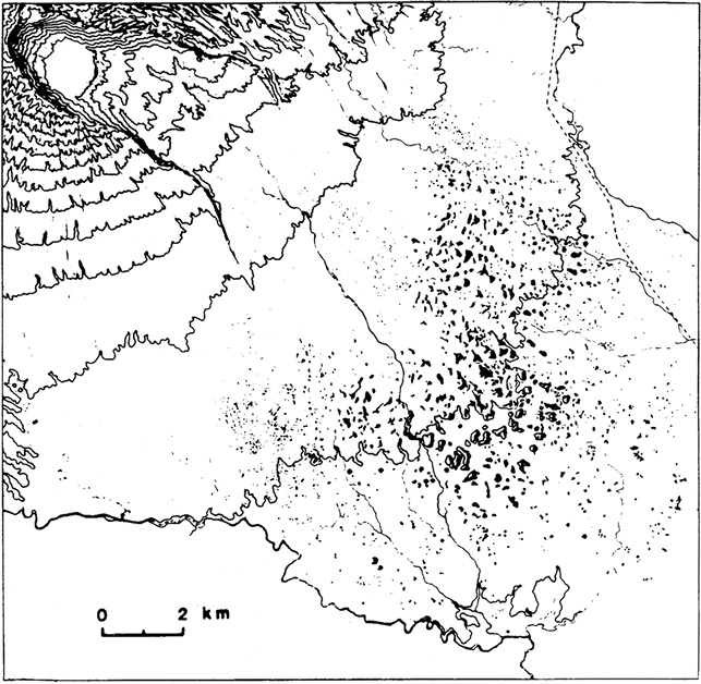
Figure 3.10. Debris-avalanche hummocks at Galunggung volcano, Java
Debris-avalanche hummocks are seen forming the ‘Ten Thousand Hills of Tasikmalaya’ downslope from the avalanche amphitheatre at Galunggung volcano, Java (Escher 1925). North is to the top of the map.
The summit ‘crater’ of Mount Lamington was observed from the north and at close quarters by an administration officer, John J. Murphy, during an ascent of the mountain from Higaturu on 29 May 1948. The purpose of the climb was to determine whether pines were growing high on the upper parts of the ‘Lamington Mountains’. Murphy reported on the details of his climb in a memorandum dated 8 February 1951—that is, not until after the major eruption of 21 January 1951—and he included a sketch (Figure 3.11) of the northern side of the summit area as it was in 1948 (Murphy 1951, 1). Three peaks were named on the sketch, these names evidently being provided by the Orokaiva men who accompanied him. Murphy wrote:
I noticed no evidence of volcanic action in recent times though the crater itself was unmistakeable as of volcanic origin. There were no signs of any activity at all in the way of earth tremors, fissures or heat, although two land slides [sic] were present on the steep Northern slope of Arunguho [Arungaho], though these were probably caused by rainfall. (Murphy 1951, 1)
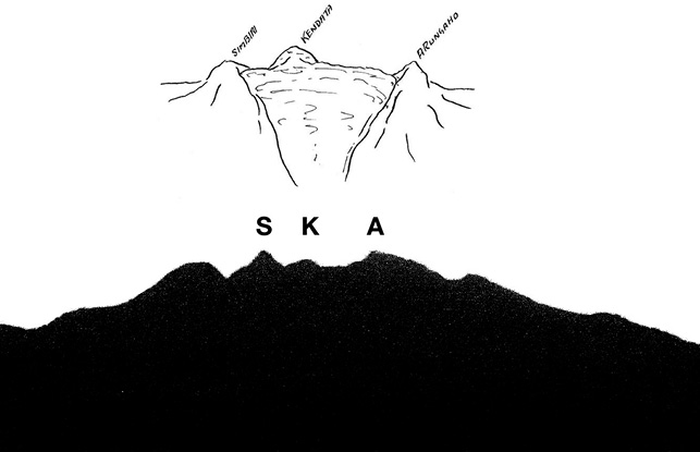
Figure 3.11. Sketch by Murphy in 1948 and silhouette of Mount Lamington
The top sketch of the volcanic crater at the summit of Mount Lamington was drawn by administration officer J.J. Murphy close-in from the north during an ascent of the mountain on 29 May 1948. The names shown are just some of the many that have been given to the peak or peaks of Mount Lamington. The lower silhouette profile of Mount Lamington and its peaks is adapted from an underexposed photograph taken from the north before the eruption of 21 January 1951. The photographer is unknown. S, K and A refer to the three peaks shown in the upper diagram. Note also the volcano-like, truncated, conical form of the rugged mountain.
The three peaks in the sketch are remnants of old lava domes. The highest of these—named ‘Kendata’, which is a village name—can also be seen on the 1947 aerial photographs where its truncated northern side forms the precipitous southern wall of the crater (Figure 3.9). Another peak, called ‘Simbiri’ on the sketch but spelt ‘Simberi’ in Murphy’s memorandum, possibly refers to Sumbiri, or Sumbiripa, the name of a spirit who lives on the mountain and who would gain much notoriety in later years. All three dome remnants form part of a stronger buttressing of the volcano’s central part compared with the less-resistant outer flanks of the mountain. They create an irregular profile that gives the false impression of an old eroded volcano rather than one of the youthful morphology of bulbous lava domes or lava flows. Taylor (1958) later noted that thermal areas could be seen clearly on the aerial photographs, grouped around the southern flank of the highest dome, but not visible from the northern side.
The short, rugged southern side of Mount Lamington that was seen by E.R. Stanley in 1916 contrasts strongly with the broad, extensive, piedmont side to the north. The south- and south-west-flowing creeks on this southern side eventually drain into the upper parts of the north-flowing Kumusi River system, as do streams on the western flank of the mountain. Similarly, creeks on the eastern side of the mountains form the Girua River that drains northwards between Lamington and the Hydrographers Range. The volcano as a whole, therefore, has a strong north to south asymmetry caused by far greater sedimentation in the north compared to the south, and evidently enhanced by the north-facing disposition of the summit crater first described by Murphy. Further, the volcano may have grown on a surface sloping gently from the foothills of the Owen Stanley Range to the north coast, which may have created a propensity to collapse gravitationally and preferentially in that same direction.
Murphy observed that:
Local history says that this crater [Figure 3.11, upper] once formed a large lake which burst through its walls on the Northern side releasing its waters which swept down and devastated several Higaturu villages and caused great loss of life. My informant puts this catastrophe at forty years ago, and it was no doubt the basis for the superstition with which Lamington Mountains were regarded by the natives. (Murphy 1951, 2)
Such a crater-wall collapse at Lamington is geologically feasible although the young date of just ‘forty years ago’ is questionable, if not unlikely. This disinterred information in any case did not gain significance until after the catastrophic volcanic eruption of 21 January 1951. Murphy, however, had identified the mountain clearly as a volcano, thus complementing suspicions interpreted after the 1951 eruption concerning the ‘roars’ from the mountain noted by the Sangara missionaries in 1935.
The hydrological hazards of the Lamington area were better known before 1951 than any threats deriving from volcanic eruptions. This is hardly surprising in a region where tropical annual rain can fall at any time of the year, but particularly in the monsoon or ‘north-west’ season. Further, large cyclones can form in the Coral Sea south of the Owen Stanley Range and their outer parts can release torrential rain onto the range and in Orokaiva country, causing rivers to swell rapidly. Anthropologist F.E. Williams, for example, wrote that:
The clear stream of yesterday is transformed overnight into a brown swirling flood, sweeping down masses of forest wreckage and rising over its banks to cover the surrounding country ... The rapidity with which the flood-waters sink is somewhat surprising when we consider the very gradual fall of the ground. (Williams 1930, 13–14)
The occasional flood, however, noted Williams (1928, 112), ‘is rather welcomed than feared’ after it recedes, as it may provide hunters with opportunities for collecting stranded frogs, fish and small game from the forest.
The Orokaiva themselves have hydrological legends, one story involving an eastward-draining river that used to flow under Mount Lamington (Horne 1974a). The ‘tunnel’ then closed after an ‘upheaval’, the water from west of the mountain began to flow into the Kumusi and the east-bound river diminished in size. Williams (1930) referred to a catastrophic flood and to a legendary being called ‘Kokowaio’ who was identified with the lake or lakes at Embi. Kokowaio, or Gogowairo, was ‘a strange creature … It was more like a gigantic turtle than anything else, and its back was covered in long grass instead of hair’ (Austen 1951, 2). The beast rescued ‘a boy and girl, the sole survivors of a flood which led to the formation of lake Embi … [and who still] exercises some sort of control over the lake, which is regarded as a place full of danger’ (Williams 1930, 277). There is some consistency between this creation legend for the lakes and the known sediment distribution north of Mount Lamington. This is because some Lamington-derived sediments have been transported north-eastwards, perhaps as mudflows, around the northern side of the Hydrographers Range. These appear to have dammed streams flowing from the northern side of the range, thus forming Embi Lakes.
Another, perhaps more important, Lamington legend was recorded in 1948 in a local, unpublished patrol report written by a Higaturu-based patrol officer, H.M. Corderoy, and published later by the anthropologist Cyril S. Belshaw (Corderoy 1948; Belshaw 1951b). This version of the story, consisting of only one short paragraph, was also told in a different form after the 1951 volcanic eruption and it achieved some considerable prominence once ‘Sumbiripa’ emerged as the name of the man concerned. It also refers to the creation of the Lamington ‘hills’:
Long ago a man, a woman and a dog went up into the area which was then flat land with no hills. The man wished to have intercourse with the woman and she consented, thereby doing wrong. They did not return to the village but lived in the area. The people did not see them again but periodically used to ask how they were by shouting into the bush. First they learnt that the dog had died, then the woman, then the man (the man’s spirit told them the last fact). The hills appeared and it was always cold and wet on top. It is not good for the people to go into the area. (Corderoy 1948, 10)
After the 1951 eruption at Lamington, Higaturu-based District Officer O.J. Atkinson wrote to the administration about his experience with earth tremors in the Northern Division at both Higaturu and Buna from 1948. He had felt many of the tremors, but they all seemed to come from the east, rather than locally. Further, he recorded that shortly before leaving Higaturu in 1949 an old man told him a story that had been handed down from his forefathers ‘that Lamington would erupt again’ (Atkinson 1951, 1). Atkinson recorded also that in 1940 at Buna he was informed that some people in the Waseta area of Mount Lamington had killed their pigs and others were about to do so. News had been spread that there was ‘going to be an eruption, that the whole countryside would be smothered, and they would lose all their pigs, gardens and lives’, so they might as well kill their pigs themselves (Atkinson 1951, 1). These stories taken at face value are evidence that the mountain Orokaiva did have a belief in the volcanic dangers of Mount Lamington. What precisely was meant by the English words ‘erupt’ and ‘eruption’, however, whether there were directly equivalent words in the Orokaiva language at the time, and what errors were made in Orokaiva-to-English translation, are unknown. Even an Orokaiva version of the word ‘volcano’, for example, does not appear in one Orokaiva dictionary compiled after the eruption (Larsen 1984), and other linguists tracing language development in proto-Oceanic society noted tentatively that Melanesians may well have ‘had no separate concept for “volcano”, regarding it simply as a mountain that produces fire’ (Osmond, Pawley and Ross 2007, 81).
The extensive piedmont of fragmental volcanic deposits on the northern footslopes of Mount Lamington contains geological evidence for past nuées ardentes of the kind that were first seen, recorded and named at Mont Pelée in the Caribbean in 1902 (Taylor 1958). Deposits from such ‘glowing clouds’—which today are called ‘pyroclastic flows’ or ‘pyroclastic density currents’—produced by eruptions at Mount Victory in the late 1880s, were almost certainly seen by William MacGregor, but by 1950 they had not yet been observed and recorded at Lamington, including in local legends. A broad generalisation that can be made today is that the structure of Mount Lamington is such that pyroclastic flows tend to be directed preferentially northwards from the north-facing crater area, downslope towards the sea. People living on the northern footslopes in early 1951 had no knowledge of such destructive volcanic phenomena, but they would soon face them and experience their terrible consequences.
Previous